Miguel Bocanegra night lights from space
Night Light of Miguel Bocanegra (Morelos) from space (Mexico) Src. Average luminocity for 10x10km area is 60.9567% and for 50x50km: 55.4876%.
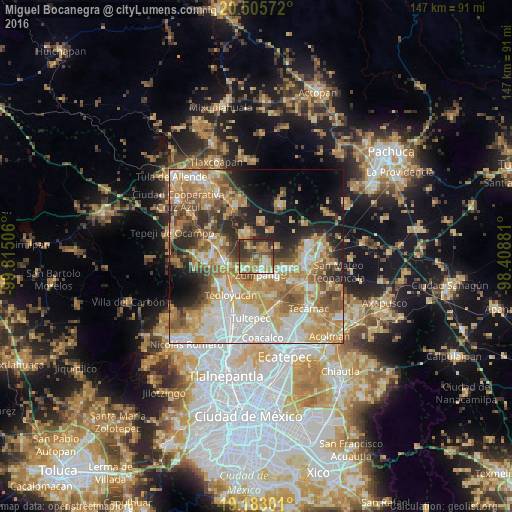
Analysis of Miguel Bocanegra night lights 2016
Square area 10x10 km:
 5.84%
5.84%90-99
6.93%80-89
12.55%70-79
9.31%60-69
19.26%50-59
11.47%40-49
11.9%30-39
14.29%20-29
8.23%10-19
0.22%0-9
0%Square area 50x50 km:
10.44%90-99
9.46%80-89
9.13%70-79
11.22%60-69
11.47%50-59
7.05%40-49
6.57%30-39
5.62%20-29
7.85%10-19
9.49%0-9
11.69%Clear (daylight) street map image can be seen on geolist.org.
Map coordinates:
20° 30' 20.6" North, 99° 48' 54.2" West
19° 50' 44.7" North, 99° 6' 42.9" West
19° 10' 58.8" North, 98° 24' 31.7" West
Some cities around Miguel Bocanegra sort by population:
• Zumpango
5.6 km =3.5 mi,  166°
166°
• Tequixquiac
7.9 km =4.9 mi,  334°
334°
• San Juan Zitlaltepec
5.1 km =3.2 mi,  222°
222°
• Fraccionamiento la Trinidad
3.6 km =2.2 mi,  121°
121°
• Ex-hacienda de Xalpa
7.9 km =4.9 mi,  250°
250°
• Jilotzingo
5.8 km =3.6 mi,  63°
63°
• San Bartolo
8.6 km =5.3 mi,  260°
260°
• Arbolada los Sauces
7.8 km =4.8 mi, 115°
3532188 (p: 5,681)
Sources (retrieved 2019-11-25):
» Earth at Night: Flat Maps 2012, 2016