Fraccionamiento la Trinidad night lights from space
Night Light of Fraccionamiento la Trinidad (México) from space (Mexico) Src. Average luminocity for 10x10km area is 69.8074% and for 50x50km: 57.2436%.
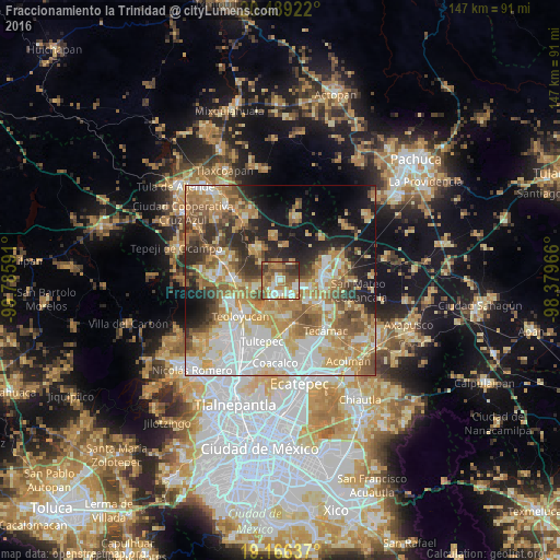
Analysis of Fraccionamiento la Trinidad night lights 2016
Square area 10x10 km:
 11.26%
90-99
12.77%80-89
13.42%70-79
11.69%60-69
16.45%50-59
12.77%40-49
10.82%30-39
9.31%20-29
1.52%10-19
0%0-9
0%Square area 50x50 km:
11.91%90-99
10.07%80-89
9.65%70-79
10.8%60-69
10.96%50-59
7.03%40-49
6.33%30-39
5.28%20-29
7.79%10-19
10.85%0-9
9.33%Clear (daylight) street map image can be seen on geolist.org.
Map coordinates:
20° 29' 21.2" North, 99° 47' 9.3" West
19° 49' 45" North, 99° 4' 58" West
19° 9' 58.9" North, 98° 22' 46.8" West
Some cities around Fraccionamiento la Trinidad sort by population:
• Zumpango
4 km =2.5 mi,  205°
205°
• San Juan Zitlaltepec
6.8 km =4.2 mi,  253°
253°
• San Bartolo Cuautlalpan
7.7 km =4.8 mi,  101°
101°
• Paseos de San Juan
8.6 km =5.3 mi,  127°
127°
• Jilotzingo
4.9 km =3 mi,  26°
26°
• San Sebastián
5.7 km =3.5 mi,  150°
150°
• Miguel Bocanegra
3.6 km =2.2 mi,  301°
301°
• Arbolada los Sauces
4.3 km =2.7 mi,  110°
110°
8858158 (p: 10,230)
Sources (retrieved 2019-11-25):
» Earth at Night: Flat Maps 2012, 2016