San Sebastián night lights from space
Night Light of San Sebastián (Morelos) from space (Mexico) Src. Average luminocity for 10x10km area is 77.4483% and for 50x50km: 62.5149%.
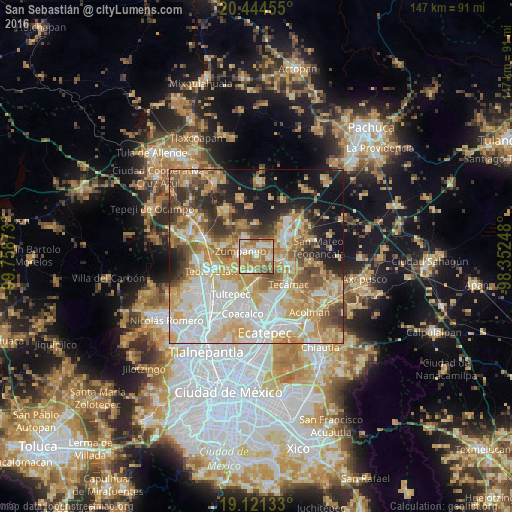
Analysis of San Sebastián night lights 2016
Square area 10x10 km:
 11.36%
90-99
16.74%80-89
14.26%70-79
16.32%60-69
28.93%50-59
10.95%40-49
1.45%30-39
0%20-29
0%10-19
0%0-9
0%Square area 50x50 km:
14.6%90-99
11.61%80-89
12.11%70-79
11.61%60-69
10.22%50-59
6.21%40-49
5.84%30-39
4.86%20-29
7.04%10-19
10.45%0-9
5.46%Clear (daylight) street map image can be seen on geolist.org.
Map coordinates:
20° 26' 40.4" North, 99° 45' 31.4" West
19° 47' 3.5" North, 99° 3' 20.2" West
19° 7' 16.8" North, 98° 21' 8.9" West
Some cities around San Sebastián sort by population:
• Zumpango
4.8 km =3 mi,  286°
286°
• Reyes Acozac
7.9 km =4.9 mi,  97°
97°
• Santa Ana Nextlalpan
5.2 km =3.2 mi,  203°
203°
• Jaltenco
5.3 km =3.3 mi,  229°
229°
• San Bartolo Cuautlalpan
5.8 km =3.6 mi,  54°
54°
• Fraccionamiento la Trinidad
5.7 km =3.5 mi,  330°
330°
• Paseos de San Juan
4 km =2.5 mi,  93°
93°
• Arbolada los Sauces
3.7 km =2.3 mi,  18°
18°
3517822 (p: 5,904)
Sources (retrieved 2019-11-25):
» Earth at Night: Flat Maps 2012, 2016