Santa Ana Nextlalpan night lights from space
Night Light of Santa Ana Nextlalpan (México) from space (Mexico) Src. Average luminocity for 10x10km area is 74.6074% and for 50x50km: 68.213%.
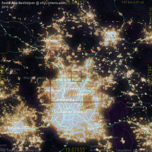
Analysis of Santa Ana Nextlalpan night lights 2016
Square area 10x10 km:
 4.34%
4.34%90-99
8.26%80-89
14.26%70-79
37.81%60-69
26.86%50-59
8.47%40-49
0%30-39
0%20-29
0%10-19
0%0-9
0%Square area 50x50 km:
19.11%90-99
13.28%80-89
12.49%70-79
12.25%60-69
9.8%50-59
5.91%40-49
5.21%30-39
4.64%20-29
7.04%10-19
8.51%0-9
1.75%Clear (daylight) street map image can be seen on geolist.org.
Map coordinates:
20° 24' 7.6" North, 99° 46' 41.1" West
19° 44' 30.2" North, 99° 4' 29.9" West
19° 4' 42.8" North, 98° 22' 18.6" West
Some cities around Santa Ana Nextlalpan sort by population:
• San Pablo de las Salinas
8.6 km =5.3 mi,  193°
193°
• Tultepec
8.4 km =5.2 mi,  221°
221°
• Zumpango
6.6 km =4.1 mi,  337°
337°
• Jaltenco
2.3 km =1.4 mi,  302°
302°
• Paseos de San Juan
7.5 km =4.7 mi,  53°
53°
• Tonanitla
6.4 km =4 mi,  159°
159°
• San Sebastián
5.2 km =3.2 mi,  23°
23°
• Ex-Hacienda Santa Inés
3.9 km =2.4 mi,  176°
176°
3517731 (p: 14,871)
Sources (retrieved 2019-11-25):
» Earth at Night: Flat Maps 2012, 2016