Ex-Hacienda Santa Inés night lights from space
Night Light of Ex-Hacienda Santa Inés (México) from space (Mexico) Src. Average luminocity for 10x10km area is 81.2851% and for 50x50km: 73.1369%.
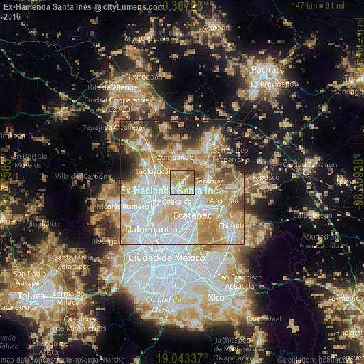
Analysis of Ex-Hacienda Santa Inés night lights 2016
Square area 10x10 km:
 16.53%
90-99
15.29%80-89
19.63%70-79
30.17%60-69
9.3%50-59
8.06%40-49
1.03%30-39
0%20-29
0%10-19
0%0-9
0%Square area 50x50 km:
23.54%90-99
14.17%80-89
12.84%70-79
12.83%60-69
10.29%50-59
5.64%40-49
4.67%30-39
3.83%20-29
5.69%10-19
5.8%0-9
0.69%Clear (daylight) street map image can be seen on geolist.org.
Map coordinates:
20° 22' 2" North, 99° 46' 32.3" West
19° 42' 24" North, 99° 4' 21" West
19° 2' 36.1" North, 98° 22' 9.8" West
Some cities around Ex-Hacienda Santa Inés sort by population:
• Ojo de Agua
7.2 km =4.5 mi,  114°
114°
• San Pablo de las Salinas
5 km =3.1 mi,  207°
207°
• Tultepec
6.3 km =3.9 mi,  247°
247°
• Santiago Teyahualco
7.6 km =4.7 mi,  226°
226°
• Alborada Jaltenco
5 km =3.1 mi,  175°
175°
• Santa Ana Nextlalpan
3.9 km =2.4 mi,  356°
356°
• Jaltenco
5.6 km =3.5 mi,  336°
336°
• Tonanitla
2.9 km =1.8 mi,  136°
136°
8858267 (p: 5,013)
Sources (retrieved 2019-11-25):
» Earth at Night: Flat Maps 2012, 2016