Ezequiel Montes night lights from space
Night Light of Ezequiel Montes (Querétaro) from space (Mexico) Src. Average luminocity for 10x10km area is 26.8712% and for 50x50km: 12.4121%.
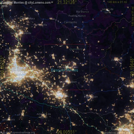
Analysis of Ezequiel Montes night lights 2016
Square area 10x10 km:
 0.76%
0.76%90-99
0.76%80-89
2.65%70-79
2.27%60-69
7.95%50-59
2.65%40-49
6.06%30-39
7.58%20-29
8.9%10-19
49.05%0-9
11.36%Square area 50x50 km:
0.16%90-99
0.38%80-89
1.95%70-79
1.75%60-69
2.26%50-59
1.6%40-49
2.62%30-39
2.67%20-29
4.74%10-19
11.96%0-9
69.92%Clear (daylight) street map image can be seen on geolist.org.
Map coordinates:
21° 19' 16.5" North, 100° 36' 9.8" West
20° 39' 53.3" North, 99° 53' 58.6" West
20° 0' 19.8" North, 99° 11' 47.3" West
Some cities around Ezequiel Montes sort by population:
• Tequisquiapan
15.8 km =9.8 mi,  177°
177°
• Cadereyta
9.4 km =5.8 mi,  67°
67°
• Colón
20.6 km =12.8 mi,  309°
309°
• Villa Progreso
7.2 km =4.5 mi,  110°
110°
• La Valla
22.6 km =14 mi,  215°
215°
• San Nicolás
21.3 km =13.2 mi,  190°
190°
• La Llave
24.2 km =15 mi,  203°
203°
• Ajuchitlán
13.4 km =8.3 mi,  290°
290°
3527656 (p: 14,053)
Sources (retrieved 2019-11-25):
» Earth at Night: Flat Maps 2012, 2016