Cadereyta night lights from space
Night Light of Cadereyta (Querétaro) from space (Mexico) Src. Average luminocity for 10x10km area is 20.4754% and for 50x50km: 9.3246%.
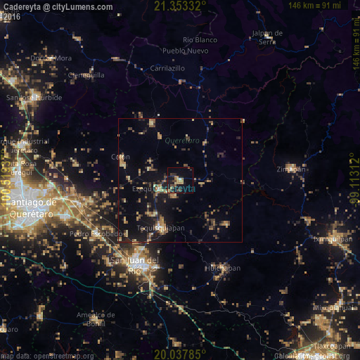
Analysis of Cadereyta night lights 2016
Square area 10x10 km:
 0.19%
0.19%90-99
0.57%80-89
1.89%70-79
4.92%60-69
4.73%50-59
1.52%40-49
4.17%30-39
3.41%20-29
5.68%10-19
21.21%0-9
51.7%Square area 50x50 km:
0.1%90-99
0.3%80-89
1.48%70-79
1.27%60-69
1.8%50-59
1.29%40-49
1.79%30-39
1.96%20-29
2.36%10-19
8.79%0-9
78.86%Clear (daylight) street map image can be seen on geolist.org.
Map coordinates:
21° 21' 12" North, 100° 31' 9.7" West
20° 41' 49.2" North, 99° 48' 58.5" West
20° 2' 16.3" North, 99° 6' 47.2" West
Some cities around Cadereyta sort by population:
• Tequisquiapan
20.9 km =13 mi,  202°
202°
• Ezequiel Montes
9.4 km =5.8 mi,  247°
247°
• Colón
26.3 km =16.3 mi,  291°
291°
• Tecozautla
26.2 km =16.3 mi,  133°
133°
• Villa Progreso
6.4 km =4 mi, 197°
• La Valla
31 km =19.3 mi,  224°
224°
• San Nicolás
27.5 km =17.1 mi,  207°
207°
• Ajuchitlán
21.2 km =13.2 mi,  273°
273°
3531863 (p: 13,347)
Sources (retrieved 2019-11-25):
» Earth at Night: Flat Maps 2012, 2016