La Llave night lights from space
Night Light of La Llave (Querétaro) from space (Mexico) Src. Average luminocity for 10x10km area is 37.6098% and for 50x50km: 21.5812%.
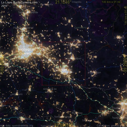
Analysis of La Llave night lights 2016
Square area 10x10 km:
 1.52%
1.52%90-99
1.7%80-89
9.85%70-79
3.41%60-69
7.77%50-59
3.79%40-49
12.12%30-39
7.95%20-29
13.83%10-19
34.09%0-9
3.98%Square area 50x50 km:
1.05%90-99
1.51%80-89
3.22%70-79
3.26%60-69
4.49%50-59
2.99%40-49
4.92%30-39
4.26%20-29
8.15%10-19
17.24%0-9
48.91%Clear (daylight) street map image can be seen on geolist.org.
Map coordinates:
21° 7' 25" North, 100° 41' 48.7" West
20° 27' 58.6" North, 99° 59' 37.4" West
19° 48' 22.1" North, 99° 17' 26.2" West
Some cities around La Llave sort by population:
• San Juan del Río
8.6 km =5.3 mi,  181°
181°
• Tequisquiapan
12.3 km =7.6 mi,  59°
59°
• Pedro Escobedo
16 km =9.9 mi,  283°
283°
• El Saúz
12.7 km =7.9 mi, 275°
• La Lira
17.5 km =10.9 mi,  273°
273°
• La Estancia
9.1 km =5.7 mi,  236°
236°
• La Valla
5.1 km =3.2 mi,  317°
317°
• San Nicolás
6 km =3.7 mi,  78°
78°
3825948 (p: 5,497)
Sources (retrieved 2019-11-25):
» Earth at Night: Flat Maps 2012, 2016