San Nicolás night lights from space
Night Light of San Nicolás (Querétaro) from space (Mexico) Src. Average luminocity for 10x10km area is 31.0284% and for 50x50km: 19.5359%.
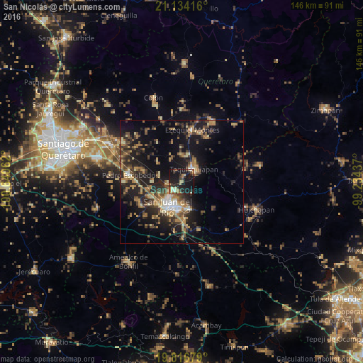
Analysis of San Nicolás night lights 2016
Square area 10x10 km:
 1.33%
1.33%90-99
0.76%80-89
7.2%70-79
4.36%60-69
6.82%50-59
0.38%40-49
5.49%30-39
7.2%20-29
11.93%10-19
47.54%0-9
7.01%Square area 50x50 km:
0.93%90-99
1.4%80-89
2.91%70-79
2.71%60-69
4.04%50-59
2.34%40-49
4.41%30-39
4.05%20-29
7.48%10-19
16.31%0-9
53.42%Clear (daylight) street map image can be seen on geolist.org.
Map coordinates:
21° 8' 3" North, 100° 38' 26.2" West
20° 28' 36.8" North, 99° 56' 15" West
19° 49' 0.4" North, 99° 14' 3.7" West
Some cities around San Nicolás sort by population:
• San Juan del Río
11.5 km =7.1 mi,  211°
211°
• Tequisquiapan
7 km =4.3 mi,  43°
43°
• Ezequiel Montes
21.3 km =13.2 mi,  10°
10°
• El Saúz
18.5 km =11.5 mi,  270°
270°
• La Estancia
14.8 km =9.2 mi,  245°
245°
• Villa Progreso
21.3 km =13.2 mi,  30°
30°
• La Valla
9.6 km =6 mi,  285°
285°
• La Llave
6 km =3.7 mi,  258°
258°
3518200 (p: 5,576)
Sources (retrieved 2019-11-25):
» Earth at Night: Flat Maps 2012, 2016