La Valla night lights from space
Night Light of La Valla (Querétaro) from space (Mexico) Src. Average luminocity for 10x10km area is 21.1894% and for 50x50km: 24.1343%.
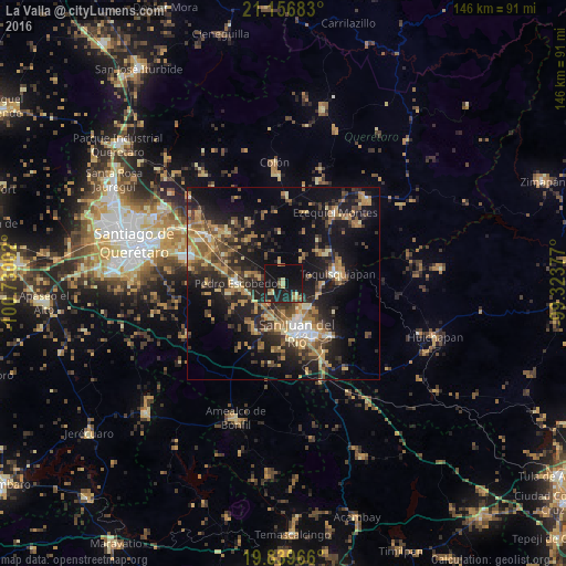
Analysis of La Valla night lights 2016
Square area 10x10 km:
 0%
0%90-99
0.38%80-89
4.92%70-79
1.89%60-69
2.65%50-59
2.46%40-49
3.79%30-39
1.89%20-29
8.52%10-19
40.15%0-9
33.33%Square area 50x50 km:
1.25%90-99
1.78%80-89
3.53%70-79
3.9%60-69
5.27%50-59
3.2%40-49
5.25%30-39
4.56%20-29
8.6%10-19
18.84%0-9
43.82%Clear (daylight) street map image can be seen on geolist.org.
Map coordinates:
21° 9' 24.6" North, 100° 43' 48.1" West
20° 29' 58.8" North, 100° 1' 36.8" West
19° 50' 22.8" North, 99° 19' 25.6" West
Some cities around La Valla sort by population:
• San Juan del Río
12.7 km =7.9 mi,  165°
165°
• Tequisquiapan
14.3 km =8.9 mi,  79°
79°
• Pedro Escobedo
12.1 km =7.5 mi,  269°
269°
• El Saúz
9.5 km =5.9 mi,  255°
255°
• La Lira
14.3 km =8.9 mi, 259°
• La Estancia
9.6 km =6 mi,  205°
205°
• San Nicolás
9.6 km =6 mi,  105°
105°
• La Llave
5.1 km =3.2 mi,  137°
137°
4029579 (p: 5,597)
Sources (retrieved 2019-11-25):
» Earth at Night: Flat Maps 2012, 2016