Colón night lights from space
Night Light of Colón (Querétaro) from space (Mexico) Src. Average luminocity for 10x10km area is 11.6155% and for 50x50km: 13.2149%.
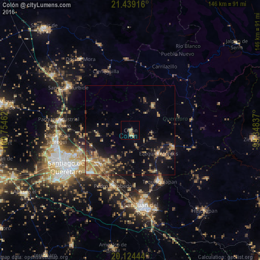
Analysis of Colón night lights 2016
Square area 10x10 km:
 0%
0%90-99
0.19%80-89
3.41%70-79
3.03%60-69
3.22%50-59
0.76%40-49
1.52%30-39
0%20-29
0.76%10-19
0.38%0-9
86.74%Square area 50x50 km:
0.46%90-99
0.77%80-89
2.05%70-79
2.17%60-69
2.91%50-59
2.13%40-49
2.97%30-39
2.16%20-29
3.45%10-19
8.62%0-9
72.32%Clear (daylight) street map image can be seen on geolist.org.
Map coordinates:
21° 26' 21" North, 100° 45' 16.6" West
20° 46' 59.6" North, 100° 3' 5.4" West
20° 7' 28" North, 99° 20' 54.1" West
Some cities around Colón sort by population:
• Ezequiel Montes
20.6 km =12.8 mi,  129°
129°
• Cadereyta
26.3 km =16.3 mi,  111°
111°
• Pedro Escobedo
32.9 km =20.4 mi,  196°
196°
• Amazcala
23.9 km =14.9 mi,  248°
248°
• Saldarriaga
30.5 km =19 mi,  235°
235°
• Villa Progreso
27.4 km =17 mi,  124°
124°
• La Valla
31.6 km =19.6 mi,  175°
175°
• Ajuchitlán
9.1 km =5.7 mi,  158°
158°
4013487 (p: 7,014)
Sources (retrieved 2019-11-25):
» Earth at Night: Flat Maps 2012, 2016