Cuichapa night lights from space
Night Light of Cuichapa (Veracruz) from space (Mexico) Src. Average luminocity for 10x10km area is 34.7489% and for 50x50km: 29.0371%.
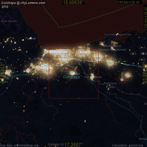
Analysis of Cuichapa night lights 2016
Square area 10x10 km:
 1.73%
1.73%90-99
6.06%80-89
4.33%70-79
3.68%60-69
3.68%50-59
6.93%40-49
9.31%30-39
9.52%20-29
14.29%10-19
23.38%0-9
17.1%Square area 50x50 km:
3.26%90-99
6.96%80-89
5.03%70-79
3.25%60-69
4.43%50-59
5.42%40-49
5.47%30-39
4.71%20-29
4.8%10-19
5.66%0-9
51.01%Clear (daylight) street map image can be seen on geolist.org.
Map coordinates:
18° 36' 23.6" North, 94° 58' 59.3" West
17° 56' 20" North, 94° 16' 48" West
17° 16' 7.3" North, 93° 34' 36.8" West
Some cities around Cuichapa sort by population:
• Coatzacoalcos
29.1 km =18.1 mi,  323°
323°
• Minatitlán
30.1 km =18.7 mi,  283°
283°
• Las Choapas
19.6 km =12.2 mi,  98°
98°
• Agua Dulce
26.4 km =16.4 mi,  32°
32°
• Nanchital de Lázaro Cárdenas del Río
20 km =12.4 mi, 317°
• Allende
26.8 km =16.7 mi,  333°
333°
• Ixhuatlán del Sureste
14.7 km =9.1 mi,  308°
308°
• Mundo Nuevo
20.3 km =12.6 mi, 324°
8858189 (p: 7,697)
Sources (retrieved 2019-11-25):
» Earth at Night: Flat Maps 2012, 2016