Ixhuatlán del Sureste night lights from space
Night Light of Ixhuatlán del Sureste (Veracruz) from space (Mexico) Src. Average luminocity for 10x10km area is 58.2446% and for 50x50km: 33.4502%.
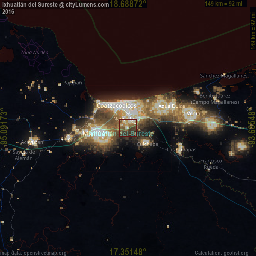
Analysis of Ixhuatlán del Sureste night lights 2016
Square area 10x10 km:
 1.3%
1.3%90-99
13.85%80-89
9.09%70-79
8.01%60-69
10.82%50-59
14.94%40-49
10.61%30-39
22.94%20-29
8.01%10-19
0.43%0-9
0%Square area 50x50 km:
3.99%90-99
7.6%80-89
5.38%70-79
3.49%60-69
4.36%50-59
5.97%40-49
7.05%30-39
6.48%20-29
6.78%10-19
9.08%0-9
39.83%Clear (daylight) street map image can be seen on geolist.org.
Map coordinates:
18° 41' 19.4" North, 95° 5' 30.2" West
18° 1' 16.9" North, 94° 23' 19" West
17° 21' 5.3" North, 93° 41' 7.7" West
Some cities around Ixhuatlán del Sureste sort by population:
• Coatzacoalcos
15.4 km =9.6 mi,  337°
337°
• Minatitlán
18 km =11.2 mi,  262°
262°
• Nanchital de Lázaro Cárdenas del Río
5.9 km =3.7 mi, 340°
• Allende
14.9 km =9.3 mi,  358°
358°
• Fraccionamiento Ciudad Olmeca
22.5 km =14 mi,  309°
309°
• Lomas de Barrillas
20.3 km =12.6 mi, 314°
• Mundo Nuevo
7.4 km =4.6 mi, 358°
• Cuichapa
14.7 km =9.1 mi,  128°
128°
11839903 (p: 10,149)
Sources (retrieved 2019-11-25):
» Earth at Night: Flat Maps 2012, 2016