Minatitlán night lights from space
Night Light of Minatitlán (Veracruz) from space (Mexico) Src. Average luminocity for 10x10km area is 88.039% and for 50x50km: 27.3931%.
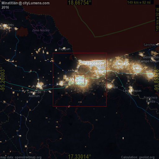

Analysis of Minatitlán night lights 2016
Square area 10x10 km:
 24.89%
90-99
30.95%80-89
20.56%70-79
10.82%60-69
7.14%50-59
5.63%40-49
0%30-39
0%20-29
0%10-19
0%0-9
0%Square area 50x50 km:
3.7%90-99
6.13%80-89
4.21%70-79
2.69%60-69
2.97%50-59
4.43%40-49
6.3%30-39
5.74%20-29
5.35%10-19
7.92%0-9
50.57%Clear (daylight) street map image can be seen on geolist.org.
Map coordinates:
18° 40' 3.1" North, 95° 15' 36.1" West
18° 0' 0.4" North, 94° 33' 24.8" West
17° 19' 48.5" North, 93° 51' 13.6" West
Some cities around Minatitlán sort by population:
• Cosoleacaque
8.4 km =5.2 mi,  269°
269°
• Fraccionamiento Ciudad Olmeca
16.7 km =10.4 mi,  1°
1°
• Oteapan
11.6 km =7.2 mi, 270°
• Zaragoza
10.2 km =6.3 mi,  242°
242°
• Lomas de Barrillas
16.8 km =10.4 mi,  11°
11°
• El Naranjito
5.3 km =3.3 mi, 267°
• Chinameca
13.2 km =8.2 mi,  280°
280°
• Coacotla
13.6 km =8.5 mi, 238°
3523183 (p: 112,046)
Sources (retrieved 2019-11-25):
» NASA, Earths city lights 1995
» NASA city lights 2003
» Earth at Night: Flat Maps 2012, 2016