Ciudad del Maíz night lights from space
Night Light of Ciudad del Maíz (San Luis Potosí) from space (Mexico) Src. Average luminocity for 10x10km area is 2.8807% and for 50x50km: 0.141%.
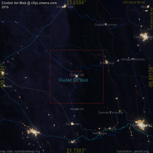
Analysis of Ciudad del Maíz night lights 2016
Square area 10x10 km:
 0%
0%90-99
0%80-89
0%70-79
0.19%60-69
2.84%50-59
0%40-49
0%30-39
0.76%20-29
0.76%10-19
0%0-9
95.45%Square area 50x50 km:
0%90-99
0%80-89
0%70-79
0.01%60-69
0.12%50-59
0%40-49
0%30-39
0.03%20-29
0.06%10-19
0.03%0-9
99.74%Clear (daylight) street map image can be seen on geolist.org.
Map coordinates:
23° 3' 1.4" North, 100° 18' 28.1" West
22° 24' 6.7" North, 99° 36' 16.8" West
21° 45' 1.1" North, 98° 54' 5.6" West
Some cities around Ciudad del Maíz sort by population:
• Rioverde
66 km =41 mi,  217°
217°
• Cárdenas
44.7 km =27.8 mi,  184°
184°
• Cerritos
70 km =43.5 mi,  272°
272°
• El Naranjo
31.4 km =19.5 mi,  63°
63°
• Xicoténcatl
94.8 km =58.9 mi,  45°
45°
• San Ciro de Acosta
86.4 km =53.7 mi,  194°
194°
• Rayón
62.2 km =38.6 mi, 183°
• Ocampo
56.5 km =35.1 mi,  28°
28°
3530598 (p: 10,391)
Sources (retrieved 2019-11-25):
» Earth at Night: Flat Maps 2012, 2016