Chontalpa night lights from space
Night Light of Chontalpa (Tabasco) from space (Mexico) Src. Average luminocity for 10x10km area is 8.8182% and for 50x50km: 3.5442%.
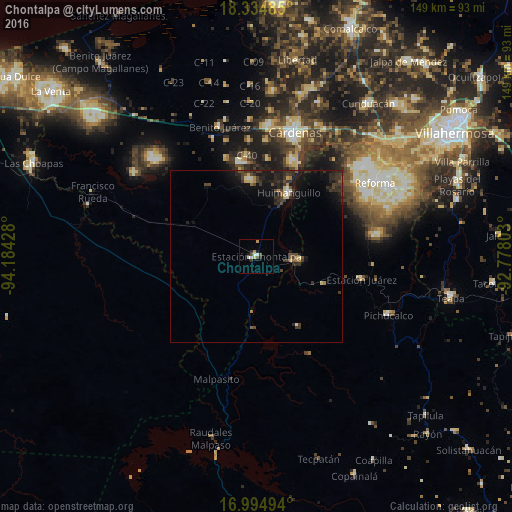
Analysis of Chontalpa night lights 2016
Square area 10x10 km:
 1.03%
1.03%90-99
2.27%80-89
0.83%70-79
1.65%60-69
0%50-59
0.41%40-49
1.86%30-39
1.03%20-29
1.65%10-19
1.65%0-9
87.6%Square area 50x50 km:
0.12%90-99
0.23%80-89
0.5%70-79
0.22%60-69
0.22%50-59
0.37%40-49
0.94%30-39
1.45%20-29
1.83%10-19
3.05%0-9
91.08%Clear (daylight) street map image can be seen on geolist.org.
Map coordinates:
18° 20' 5.5" North, 94° 11' 3.4" West
17° 39' 58.1" North, 93° 28' 52.1" West
16° 59' 41.8" North, 92° 46' 40.9" West
Some cities around Chontalpa sort by population:
• Cárdenas
38.9 km =24.2 mi,  16°
16°
• Huimanguillo
21 km =13 mi,  27°
27°
• Reforma
41.6 km =25.8 mi,  57°
57°
• Pichucalco
42.4 km =26.3 mi,  114°
114°
• Juárez
31.1 km =19.3 mi,  102°
102°
• Raudales Malpaso
54.7 km =34 mi,  193°
193°
• Luis Gil Pérez
49.2 km =30.6 mi, 61°
• Santa Rosalía
48.7 km =30.3 mi, 15°
3530749 (p: 7,336)
Sources (retrieved 2019-11-25):
» Earth at Night: Flat Maps 2012, 2016