Raudales Malpaso night lights from space
Night Light of Raudales Malpaso (Chiapas) from space (Mexico) Src. Average luminocity for 10x10km area is 3.4153% and for 50x50km: 0.3155%.
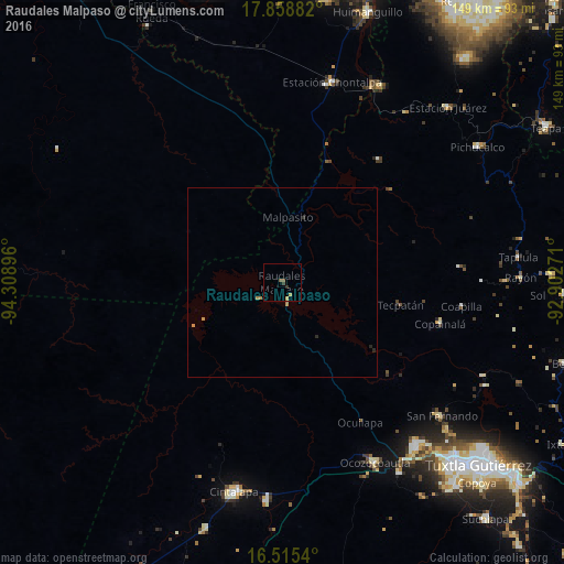
Analysis of Raudales Malpaso night lights 2016
Square area 10x10 km:
 0%
0%90-99
0%80-89
0%70-79
1.86%60-69
0.21%50-59
1.65%40-49
0%30-39
1.03%20-29
0.62%10-19
0%0-9
94.63%Square area 50x50 km:
0%90-99
0%80-89
0%70-79
0.21%60-69
0.05%50-59
0.06%40-49
0%30-39
0.04%20-29
0.15%10-19
0%0-9
99.48%Clear (daylight) street map image can be seen on geolist.org.
Map coordinates:
17° 51' 31.8" North, 94° 18' 32.3" West
17° 11' 18" North, 93° 36' 21" West
16° 30' 55.4" North, 92° 54' 9.8" West
Some cities around Raudales Malpaso sort by population:
• Cintalapa de Figueroa
57.3 km =35.6 mi,  192°
192°
• Ocozocoautla de Espinosa
53.4 km =33.2 mi,  152°
152°
• Berriozábal
56 km =34.8 mi,  140°
140°
• Jiquipilas
58 km =36 mi,  184°
184°
• San Fernando
55.1 km =34.2 mi,  129°
129°
• Tapilula
62.9 km =39.1 mi,  83°
83°
• Chontalpa
54.7 km =34 mi,  13°
13°
• Copainalá
43.3 km =26.9 mi,  104°
104°
8858206 (p: 6,817)
Sources (retrieved 2019-11-25):
» Earth at Night: Flat Maps 2012, 2016