Santa Rosalía night lights from space
Night Light of Santa Rosalía (Tabasco) from space (Mexico) Src. Average luminocity for 10x10km area is 39.6017% and for 50x50km: 32.8497%.
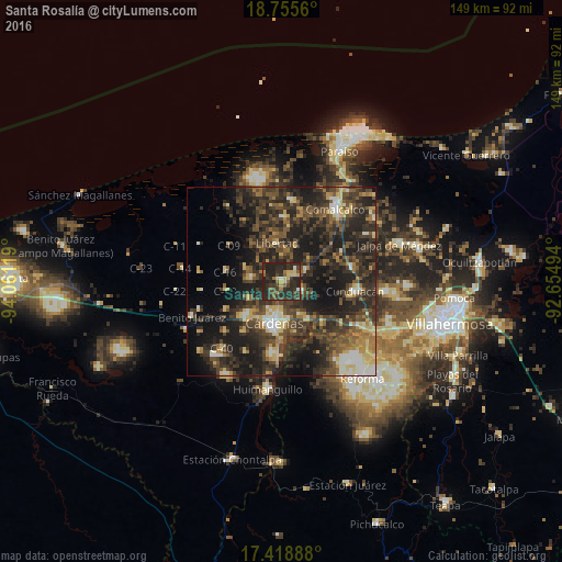
Analysis of Santa Rosalía night lights 2016
Square area 10x10 km:
 0.22%
0.22%90-99
2.6%80-89
10.17%70-79
1.52%60-69
4.98%50-59
5.84%40-49
8.66%30-39
15.15%20-29
45.67%10-19
5.19%0-9
0%Square area 50x50 km:
1.46%90-99
3.76%80-89
4.95%70-79
2.53%60-69
4.05%50-59
5.69%40-49
9.39%30-39
12.78%20-29
17.22%10-19
18.99%0-9
19.17%Clear (daylight) street map image can be seen on geolist.org.
Map coordinates:
18° 45' 20.2" North, 94° 3' 40.3" West
18° 5' 18.6" North, 93° 21' 29" West
17° 25' 8" North, 92° 39' 17.8" West
Some cities around Santa Rosalía sort by population:
• Cárdenas
9.9 km =6.2 mi,  190°
190°
• Comalcalco
24 km =14.9 mi,  36°
36°
• Huimanguillo
28.5 km =17.7 mi, 186°
• Cunduacán
19.7 km =12.2 mi,  97°
97°
• Villa Tecolutilla
21.8 km =13.5 mi,  6°
6°
• Chichicapa
26.8 km =16.7 mi, 43°
• Miguel Hidalgo
19.4 km =12.1 mi, 14°
• Villa Aldama
17 km =10.6 mi,  2°
2°
3517029 (p: 5,528)
Sources (retrieved 2019-11-25):
» Earth at Night: Flat Maps 2012, 2016