Chanal night lights from space
Night Light of Chanal (Chiapas) from space (Mexico) Src. Average luminocity for 10x10km area is 0.0346% and for 50x50km: 4.5957%.
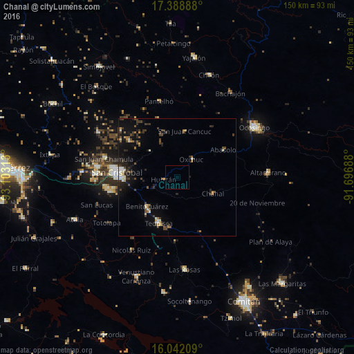
Analysis of Chanal night lights 2016
Square area 10x10 km:
 0%
0%90-99
0%80-89
0%70-79
0%60-69
0%50-59
0%40-49
0%30-39
0%20-29
0%10-19
0%0-9
100%Square area 50x50 km:
0.13%90-99
0.91%80-89
0.35%70-79
0.35%60-69
0.45%50-59
0.55%40-49
1.26%30-39
1.05%20-29
1.21%10-19
3.64%0-9
90.1%Clear (daylight) street map image can be seen on geolist.org.
Map coordinates:
17° 23' 20" North, 93° 6' 11.3" West
16° 43' 0" North, 92° 24' 0" West
16° 2' 31.5" North, 91° 41' 48.8" West
Some cities around Chanal sort by population:
• San Cristóbal de las Casas
25.7 km =16 mi,  273°
273°
• Ocosingo
38.8 km =24.1 mi,  57°
57°
• Teopisca
21 km =13 mi,  202°
202°
• Altamirano
38.6 km =24 mi,  87°
87°
• Pantelhó
33 km =20.5 mi,  346°
346°
• Oxchuc
9.7 km =6 mi,  37°
37°
• Altamirano
32.4 km =20.1 mi, 55°
• San Juan Cancuc
19.8 km =12.3 mi,  9°
9°
3531168 (p: 5,592)
Sources (retrieved 2019-11-25):
» Earth at Night: Flat Maps 2012, 2016