Pantelhó night lights from space
Night Light of Pantelhó (Chiapas) from space (Mexico) Src. Average luminocity for 10x10km area is 2.7121% and for 50x50km: 5.0101%.
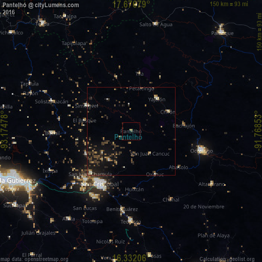
Analysis of Pantelhó night lights 2016
Square area 10x10 km:
 0%
0%90-99
0%80-89
0%70-79
1.73%60-69
0%50-59
0%40-49
0.87%30-39
0.65%20-29
0.43%10-19
0.65%0-9
95.67%Square area 50x50 km:
0.02%90-99
0.52%80-89
0.41%70-79
0.5%60-69
0.5%50-59
0.72%40-49
1.48%30-39
1.77%20-29
1.55%10-19
5.32%0-9
87.21%Clear (daylight) street map image can be seen on geolist.org.
Map coordinates:
17° 40' 36.4" North, 93° 10' 29.2" West
17° 0' 20.3" North, 92° 28' 17.9" West
16° 19' 55.4" North, 91° 46' 6.7" West
Some cities around Pantelhó sort by population:
• Yajalón
23.7 km =14.7 mi,  38°
38°
• Simojovel de Allende
29.8 km =18.5 mi,  300°
300°
• Chilón
23.9 km =14.9 mi,  62°
62°
• Petalcingo
25.4 km =15.8 mi,  13°
13°
• Oxchuc
27.9 km =17.3 mi,  151°
151°
• San Juan Cancuc
16.6 km =10.3 mi,  139°
139°
• Chilón
26 km =16.2 mi, 12°
• El Bosque
27.3 km =17 mi,  283°
283°
3517659 (p: 6,888)
Sources (retrieved 2019-11-25):
» Earth at Night: Flat Maps 2012, 2016