Altamirano night lights from space
Night Light of Altamirano (Chiapas) from space (Mexico) Src. Average luminocity for 10x10km area is 5.7056% and for 50x50km: 1.8783%.
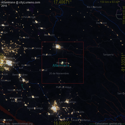
Analysis of Altamirano night lights 2016
Square area 10x10 km:
 0%
0%90-99
0.87%80-89
1.73%70-79
0.87%60-69
0.87%50-59
0.87%40-49
1.08%30-39
0.65%20-29
0%10-19
0.87%0-9
92.21%Square area 50x50 km:
0.16%90-99
0.27%80-89
0.33%70-79
0.24%60-69
0.1%50-59
0.19%40-49
0.47%30-39
0.3%20-29
0.31%10-19
1.18%0-9
96.45%Clear (daylight) street map image can be seen on geolist.org.
Map coordinates:
17° 24' 24.2" North, 92° 44' 29.6" West
16° 44' 4.5" North, 92° 2' 18.3" West
16° 3' 36.2" North, 91° 20' 7.1" West
Some cities around Altamirano sort by population:
• Ocosingo
20 km =12.4 mi,  342°
342°
• Las Margaritas
47.3 km =29.4 mi,  172°
172°
• Chilón
48.2 km =30 mi,  328°
328°
• Chanal
24.9 km =15.5 mi,  249°
249°
• Oxchuc
33.1 km =20.6 mi,  279°
279°
• San Juan Cancuc
39.4 km =24.5 mi,  296°
296°
• Chanal
38.6 km =24 mi,  267°
267°
• Bachajón
37.6 km =23.4 mi, 334°
3816251 (p: 9,200)
Sources (retrieved 2019-11-25):
» Earth at Night: Flat Maps 2012, 2016