Cuitzeo del Porvenir night lights from space
Night Light of Cuitzeo del Porvenir (Michoacán) from space (Mexico) Src. Average luminocity for 10x10km area is 7.4913% and for 50x50km: 10.3266%.
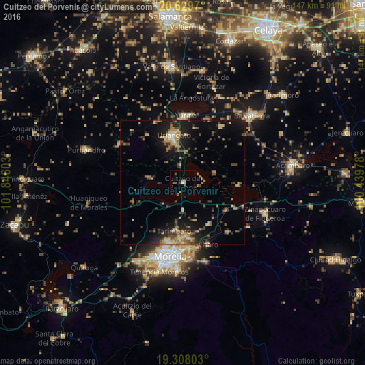
Analysis of Cuitzeo del Porvenir night lights 2016
Square area 10x10 km:
 0.65%
0.65%90-99
0.22%80-89
0%70-79
1.73%60-69
2.16%50-59
1.08%40-49
2.38%30-39
0.87%20-29
0%10-19
0.65%0-9
90.26%Square area 50x50 km:
0.16%90-99
0.65%80-89
1.74%70-79
1.56%60-69
2.11%50-59
1.28%40-49
2.09%30-39
1.52%20-29
3.04%10-19
8.1%0-9
77.75%Clear (daylight) street map image can be seen on geolist.org.
Map coordinates:
20° 37' 46.9" North, 101° 50' 45.7" West
19° 58' 12.9" North, 101° 8' 34.4" West
19° 18' 28.9" North, 100° 26' 23.2" West
Some cities around Cuitzeo del Porvenir sort by population:
• Uriangato
19.4 km =12.1 mi,  347°
347°
• Moroleón
18 km =11.2 mi,  343°
343°
• Álvaro Obregón
19.8 km =12.3 mi,  147°
147°
• Estación Queréndaro
22.5 km =14 mi,  115°
115°
• Fraccionamiento Misión del Valle
22.9 km =14.2 mi,  174°
174°
• Santa Ana Maya
13.3 km =8.3 mi,  72°
72°
• Huandacareo
14.1 km =8.8 mi,  279°
279°
• Tarímbaro
19.7 km =12.2 mi,  190°
190°
4012194 (p: 10,239)
Sources (retrieved 2019-11-25):
» Earth at Night: Flat Maps 2012, 2016