Huandacareo night lights from space
Night Light of Huandacareo (Michoacán) from space (Mexico) Src. Average luminocity for 10x10km area is 4.5893% and for 50x50km: 8.9154%.
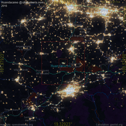
Analysis of Huandacareo night lights 2016
Square area 10x10 km:
 0%
0%90-99
0%80-89
0.4%70-79
0.6%60-69
2.18%50-59
0.6%40-49
0.79%30-39
0.99%20-29
1.98%10-19
0.79%0-9
91.67%Square area 50x50 km:
0.15%90-99
0.48%80-89
1.55%70-79
1.28%60-69
1.82%50-59
1.04%40-49
1.97%30-39
1.52%20-29
2.54%10-19
7.22%0-9
80.42%Clear (daylight) street map image can be seen on geolist.org.
Map coordinates:
20° 39' 2.6" North, 101° 58' 45.2" West
19° 59' 28.9" North, 101° 16' 34" West
19° 19' 45.2" North, 100° 34' 22.7" West
Some cities around Huandacareo sort by population:
• Uriangato
19.3 km =12 mi,  30°
30°
• Moroleón
17.3 km =10.7 mi, 30°
• Cuitzeo del Porvenir
14.1 km =8.8 mi,  99°
99°
• Santa Ana Maya
26.6 km =16.5 mi,  86°
86°
• Cerano
17.5 km =10.9 mi,  318°
318°
• Tarímbaro
24.1 km =15 mi,  154°
154°
• Fraccionamiento Galaxia Tarímbaro
26.9 km =16.7 mi,  161°
161°
• Fraccionamiento Metrópolis II
27.2 km =16.9 mi, 163°
4004690 (p: 6,736)
Sources (retrieved 2019-11-25):
» Earth at Night: Flat Maps 2012, 2016