La Cabecera night lights from space
Night Light of La Cabecera (México) from space (Mexico) Src. Average luminocity for 10x10km area is 56.2045% and for 50x50km: 32.8816%.
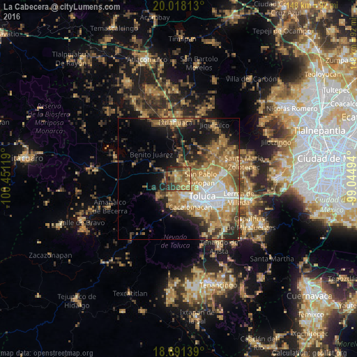
Analysis of La Cabecera night lights 2016
Square area 10x10 km:
 0.41%
0.41%90-99
0.62%80-89
11.36%70-79
11.78%60-69
26.86%50-59
13.02%40-49
13.84%30-39
11.98%20-29
8.26%10-19
1.86%0-9
0%Square area 50x50 km:
4.04%90-99
3.78%80-89
5.11%70-79
6.73%60-69
9.05%50-59
4.64%40-49
5.17%30-39
3.86%20-29
6.42%10-19
10.96%0-9
40.25%Clear (daylight) street map image can be seen on geolist.org.
Map coordinates:
20° 1' 5.3" North, 100° 27' 4.3" West
19° 21' 22" North, 99° 44' 53" West
18° 41' 29" North, 99° 2' 41.8" West
Some cities around La Cabecera sort by population:
• Zinacantepec
8.1 km =5 mi,  169°
169°
• San Francisco Tlalcilalcalpan
7.1 km =4.4 mi,  196°
196°
• Calixtlahuaca
6.5 km =4 mi,  109°
109°
• Santiaguito Tlalcilalcalli
2.8 km =1.7 mi,  128°
128°
• Ejido San Lorenzo Cuauhtenco
6.1 km =3.8 mi,  182°
182°
• Fraccionamiento Colinas del Sol
2 km =1.2 mi,  24°
24°
• Conjunto Urbano la Loma I
3.7 km =2.3 mi,  152°
152°
• San Marcos Yachihuacaltepec
8.1 km =5 mi,  116°
116°
3827250 (p: 6,559)
Sources (retrieved 2019-11-25):
» Earth at Night: Flat Maps 2012, 2016