Fraccionamiento Colinas del Sol night lights from space
Night Light of Fraccionamiento Colinas del Sol (México) from space (Mexico) Src. Average luminocity for 10x10km area is 56.312% and for 50x50km: 34.1851%.
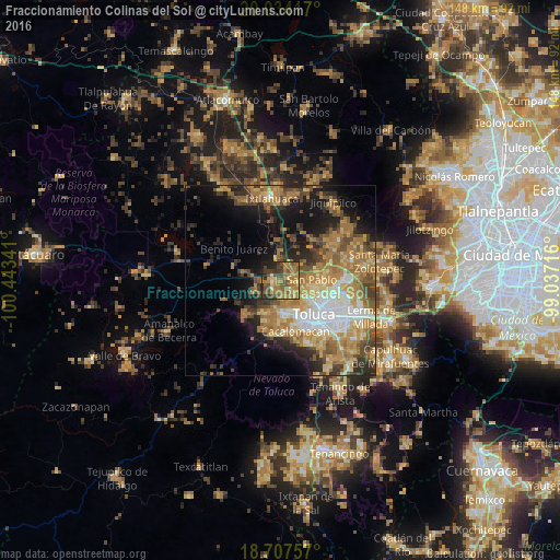
Analysis of Fraccionamiento Colinas del Sol night lights 2016
Square area 10x10 km:
 0.41%
0.41%90-99
0.62%80-89
11.78%70-79
12.19%60-69
27.48%50-59
12.6%40-49
13.64%30-39
8.47%20-29
8.26%10-19
4.55%0-9
0%Square area 50x50 km:
4.09%90-99
3.79%80-89
5.26%70-79
7.14%60-69
9.54%50-59
4.86%40-49
5.55%30-39
4.17%20-29
6.54%10-19
11.53%0-9
37.54%Clear (daylight) street map image can be seen on geolist.org.
Map coordinates:
20° 2' 3" North, 100° 26' 36.3" West
19° 22' 20" North, 99° 44' 25" West
18° 42' 27.3" North, 99° 2' 13.8" West
Some cities around Fraccionamiento Colinas del Sol sort by population:
• San Pablo Autopan
8.9 km =5.5 mi,  101°
101°
• San Francisco Tlalcilalcalpan
9.1 km =5.7 mi,  198°
198°
• Calixtlahuaca
6.7 km =4.2 mi,  126°
126°
• Santiaguito Tlalcilalcalli
3.8 km =2.4 mi,  158°
158°
• Ejido San Lorenzo Cuauhtenco
7.9 km =4.9 mi,  187°
187°
• La Cabecera
2 km =1.2 mi, 204°
• Conjunto Urbano la Loma I
5.2 km =3.2 mi,  170°
170°
• San Marcos Yachihuacaltepec
8.4 km =5.2 mi, 130°
8858212 (p: 6,640)
Sources (retrieved 2019-11-25):
» Earth at Night: Flat Maps 2012, 2016