Cacalchen night lights from space
Night Light of Cacalchen (Yucatán) from space (Mexico) Src. Average luminocity for 10x10km area is 6.3512% and for 50x50km: 6.566%.
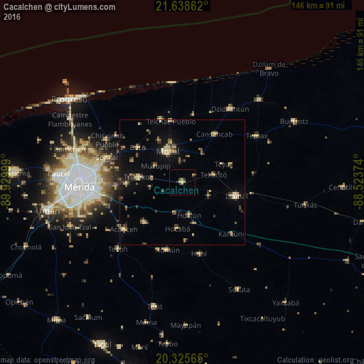
Analysis of Cacalchen night lights 2016
Square area 10x10 km:
 0%
0%90-99
0.79%80-89
0.99%70-79
1.79%60-69
1.59%50-59
0%40-49
0.79%30-39
0.4%20-29
2.38%10-19
0.4%0-9
90.87%Square area 50x50 km:
0.04%90-99
0.3%80-89
1.77%70-79
0.73%60-69
0.76%50-59
0.86%40-49
1.43%30-39
1.09%20-29
0.97%10-19
3.39%0-9
88.65%Clear (daylight) street map image can be seen on geolist.org.
Map coordinates:
21° 38' 19" North, 89° 55' 48" West
20° 59' 0.9" North, 89° 13' 36.7" West
20° 19' 32.3" North, 88° 31' 25.5" West
Some cities around Cacalchen sort by population:
• Kanasín
34.9 km =21.7 mi,  261°
261°
• Motul
13.8 km =8.6 mi,  334°
334°
• Izamal
22.3 km =13.9 mi,  103°
103°
• Acanceh
30.2 km =18.8 mi,  231°
231°
• Tixkokob
17.6 km =10.9 mi,  276°
276°
• Seyé
22.3 km =13.9 mi,  222°
222°
• Conkal
32 km =19.9 mi,  288°
288°
• Homun
27.8 km =17.3 mi,  192°
192°
3531892 (p: 6,787)
Sources (retrieved 2019-11-25):
» Earth at Night: Flat Maps 2012, 2016