Homun night lights from space
Night Light of Homun (Yucatán) from space (Mexico) Src. Average luminocity for 10x10km area is 6.9545% and for 50x50km: 3.4693%.
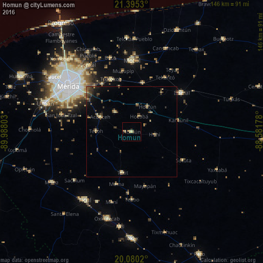
Analysis of Homun night lights 2016
Square area 10x10 km:
100  0%
0%
90-99 0.57%
80-89 2.46%
70-79 1.14%
60-69 1.14%
50-59 0.95%
40-49 1.33%
30-39 0%
20-29 0.76%
10-19 0.76%
0-9 90.91%
0%90-99
0.57%80-89
2.46%70-79
1.14%60-69
1.14%50-59
0.95%40-49
1.33%30-39
0%20-29
0.76%10-19
0.76%0-9
90.91%Square area 50x50 km:
100 0%
90-99 0.18%
80-89 0.72%
70-79 0.44%
60-69 0.38%
50-59 0.37%
40-49 1.23%
30-39 0.81%
20-29 0.65%
10-19 1.34%
0-9 93.89%
0%90-99
0.18%80-89
0.72%70-79
0.44%60-69
0.38%50-59
0.37%40-49
1.23%30-39
0.81%20-29
0.65%10-19
1.34%0-9
93.89%Clear (daylight) street map image can be seen on geolist.org.
Map coordinates:
21° 23' 43.1" North, 89° 59' 16.9" West
20° 44' 21" North, 89° 17' 5.6" West
20° 4' 48.7" North, 88° 34' 54.4" West
Some cities around Homun sort by population:
• Izamal
35.3 km =21.9 mi,  51°
51°
• Tixkokob
31.4 km =19.5 mi,  338°
338°
• Acanceh
19.3 km =12 mi,  295°
295°
• Tekit
23.3 km =14.5 mi,  192°
192°
• Tekoh
19.7 km =12.2 mi,  271°
271°
• Seyé
14 km =8.7 mi,  319°
319°
• Cacalchen
27.8 km =17.3 mi,  12°
12°
• Sotuta
32.9 km =20.4 mi,  118°
118°
3527080 (p: 6,146)
Sources (retrieved 2019-11-25):
» Earth at Night: Flat Maps 2012, 2016