Tixkokob night lights from space
Night Light of Tixkokob (Yucatán) from space (Mexico) Src. Average luminocity for 10x10km area is 17.9306% and for 50x50km: 20.0164%.
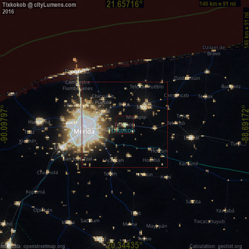
Analysis of Tixkokob night lights 2016
Square area 10x10 km:
 0%
0%90-99
0.6%80-89
7.34%70-79
0.79%60-69
0.6%50-59
2.58%40-49
1.59%30-39
5.36%20-29
2.98%10-19
12.7%0-9
65.48%Square area 50x50 km:
4.16%90-99
2.67%80-89
4.66%70-79
1.51%60-69
1.87%50-59
2.43%40-49
3.2%30-39
2.43%20-29
3.05%10-19
7.95%0-9
66.09%Clear (daylight) street map image can be seen on geolist.org.
Map coordinates:
21° 39' 25.8" North, 90° 5' 52.7" West
21° 0' 7.9" North, 89° 23' 41.4" West
20° 20' 39.7" North, 88° 41' 30.2" West
Some cities around Tixkokob sort by population:
• Mérida
23.3 km =14.5 mi,  262°
262°
• Kanasín
18.6 km =11.6 mi,  246°
246°
• Motul
15.6 km =9.7 mi,  48°
48°
• Acanceh
21.9 km =13.6 mi,  195°
195°
• Seyé
18.7 km =11.6 mi,  172°
172°
• Conkal
15.2 km =9.4 mi,  301°
301°
• Cacalchen
17.6 km =10.9 mi,  96°
96°
• Cholul
17.6 km =10.9 mi,  284°
284°
3515521 (p: 10,968)
Sources (retrieved 2019-11-25):
» Earth at Night: Flat Maps 2012, 2016