Seyé night lights from space
Night Light of Seyé (Yucatán) from space (Mexico) Src. Average luminocity for 10x10km area is 6.4702% and for 50x50km: 12.6529%.
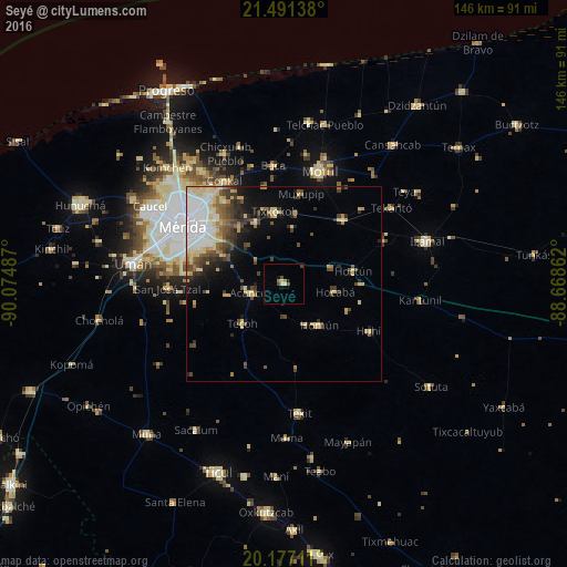
Analysis of Seyé night lights 2016
Square area 10x10 km:
100  0%
0%
90-99 0.99%
80-89 1.39%
70-79 0%
60-69 1.59%
50-59 0.79%
40-49 2.18%
30-39 0.2%
20-29 0%
10-19 1.98%
0-9 90.87%
0%90-99
0.99%80-89
1.39%70-79
0%60-69
1.59%50-59
0.79%40-49
2.18%30-39
0.2%20-29
0%10-19
1.98%0-9
90.87%Square area 50x50 km:
100 2.71%
90-99 1.67%
80-89 2.8%
70-79 0.98%
60-69 1.19%
50-59 1.31%
40-49 2.22%
30-39 1.98%
20-29 1.78%
10-19 3.88%
0-9 79.5%
2.71%90-99
1.67%80-89
2.8%70-79
0.98%60-69
1.19%50-59
1.31%40-49
2.22%30-39
1.98%20-29
1.78%10-19
3.88%0-9
79.5%Clear (daylight) street map image can be seen on geolist.org.
Map coordinates:
21° 29' 29" North, 90° 4' 29.5" West
20° 50' 8.4" North, 89° 22' 18.3" West
20° 10' 37.6" North, 88° 40' 7" West
Some cities around Seyé sort by population:
• Mérida
29.8 km =18.5 mi,  301°
301°
• Kanasín
22.3 km =13.9 mi, 299°
• Tixkokob
18.7 km =11.6 mi,  352°
352°
• Acanceh
8.8 km =5.5 mi,  253°
253°
• Tekoh
14.8 km =9.2 mi,  226°
226°
• Cacalchen
22.3 km =13.9 mi,  42°
42°
• Homun
14 km =8.7 mi,  139°
139°
• Cholul
30.1 km =18.7 mi,  319°
319°
3516683 (p: 8,369)
Sources (retrieved 2019-11-25):
» Earth at Night: Flat Maps 2012, 2016