Les Trois-Îlets night lights from space
Night Light of Les Trois-Îlets (Martinique) from space (Martinique) Src. Average luminocity for 10x10km area is 32.6147% and for 50x50km: 18.7937%.
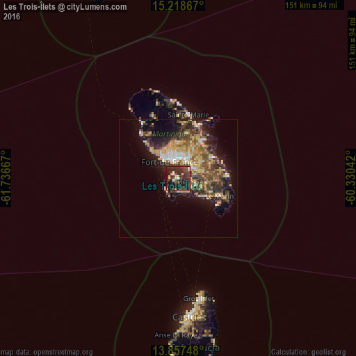
Analysis of Les Trois-Îlets night lights 2016
Square area 10x10 km:
 1.73%
1.73%90-99
3.03%80-89
5.84%70-79
1.3%60-69
1.08%50-59
1.08%40-49
4.55%30-39
17.53%20-29
35.71%10-19
27.49%0-9
0.65%Square area 50x50 km:
1.53%90-99
1.74%80-89
3.95%70-79
3.62%60-69
2.31%50-59
2.53%40-49
3.63%30-39
4.52%20-29
5.43%10-19
9.66%0-9
61.08%Clear (daylight) street map image can be seen on geolist.org.
Map coordinates:
15° 13' 7.2" North, 61° 44' 12" West
14° 32' 20.8" North, 61° 2' 0.7" West
13° 51' 26.9" North, 60° 19' 49.5" West
Some cities around Les Trois-Îlets sort by population:
• Fort-de-France
8.4 km =5.2 mi,  328°
328°
• Le Lamentin
9 km =5.6 mi,  23°
23°
• Le François
16.4 km =10.2 mi,  58°
58°
• Ducos
7.5 km =4.7 mi, 57°
• Saint-Joseph
14.7 km =9.1 mi,  357°
357°
• Rivière-Pilote
15.2 km =9.4 mi,  112°
112°
• Sainte-Luce
14.4 km =8.9 mi,  123°
123°
• Saint-Esprit
10.9 km =6.8 mi,  83°
83°
3570396 (p: 5,657)
Sources (retrieved 2019-11-25):
» Earth at Night: Flat Maps 2012, 2016