Sainte-Luce night lights from space
Night Light of Sainte-Luce (Martinique) from space (Martinique) Src. Average luminocity for 10x10km area is 37.0909% and for 50x50km: 16.1576%.
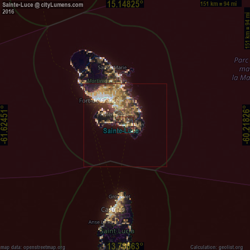
Analysis of Sainte-Luce night lights 2016
Square area 10x10 km:
 2.16%
2.16%90-99
1.95%80-89
4.55%70-79
9.52%60-69
4.11%50-59
5.41%40-49
9.74%30-39
13.42%20-29
14.07%10-19
22.94%0-9
12.12%Square area 50x50 km:
1.43%90-99
1.56%80-89
3.57%70-79
3.3%60-69
1.96%50-59
2.33%40-49
3.25%30-39
3.4%20-29
4.45%10-19
6.81%0-9
67.94%Clear (daylight) street map image can be seen on geolist.org.
Map coordinates:
15° 8' 53.7" North, 61° 37' 28.2" West
14° 28' 6.5" North, 60° 55' 17" West
13° 47' 11.9" North, 60° 13' 5.7" West
Some cities around Sainte-Luce sort by population:
• Fort-de-France
22.3 km =13.9 mi,  312°
312°
• Le Lamentin
18.2 km =11.3 mi,  332°
332°
• Le François
16.4 km =10.2 mi,  6°
6°
• Ducos
13.2 km =8.2 mi, 334°
• Rivière-Pilote
2.9 km =1.8 mi,  43°
43°
• Le Marin
5.6 km =3.5 mi,  86°
86°
• Le Vauclin
12.4 km =7.7 mi,  46°
46°
• Les Trois-Îlets
14.4 km =8.9 mi,  303°
303°
3569928 (p: 9,196)
Sources (retrieved 2019-11-25):
» Earth at Night: Flat Maps 2012, 2016