La Trinité night lights from space
Night Light of La Trinité (Martinique) from space (Martinique) Src. Average luminocity for 10x10km area is 38.8409% and for 50x50km: 17.4009%.
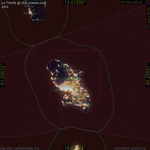
Analysis of La Trinité night lights 2016
Square area 10x10 km:
 2.48%
2.48%90-99
3.72%80-89
5.37%70-79
6.61%60-69
7.23%50-59
4.96%40-49
6.61%30-39
15.08%20-29
14.26%10-19
27.27%0-9
6.4%Square area 50x50 km:
1.49%90-99
1.76%80-89
3.66%70-79
3.3%60-69
2.17%50-59
2.32%40-49
3.22%30-39
4.01%20-29
4.72%10-19
8.36%0-9
65%Clear (daylight) street map image can be seen on geolist.org.
Map coordinates:
15° 25' 1.2" North, 61° 39' 58.8" West
14° 44' 17.1" North, 60° 57' 47.5" West
14° 3' 25.3" North, 60° 15' 36.3" West
Some cities around La Trinité sort by population:
• Le Lamentin
14.4 km =8.9 mi,  195°
195°
• Le Robert
7.1 km =4.4 mi,  161°
161°
• Sainte-Marie
5.9 km =3.7 mi,  328°
328°
• Le François
15.1 km =9.4 mi,  154°
154°
• Ducos
18.1 km =11.2 mi,  183°
183°
• Saint-Joseph
11.1 km =6.9 mi,  227°
227°
• Le Gros-Morne
5.8 km =3.6 mi,  223°
223°
• Le Lorrain
14.5 km =9 mi,  316°
316°
3570446 (p: 15,040)
Sources (retrieved 2019-11-25):
» Earth at Night: Flat Maps 2012, 2016