Ngong night lights from space
Night Light of Ngong (Kajiado) from space (Kenya) Src. Average luminocity for 10x10km area is 32.6407% and for 50x50km: 19.3698%.
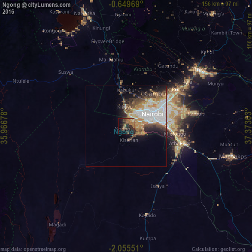
Analysis of Ngong night lights 2016
Square area 10x10 km:
 0%
0%90-99
1.73%80-89
3.03%70-79
1.73%60-69
18.4%50-59
1.3%40-49
9.52%30-39
5.84%20-29
19.7%10-19
16.67%0-9
22.08%Square area 50x50 km:
4.47%90-99
4.07%80-89
1.73%70-79
2.47%60-69
3.63%50-59
2.09%40-49
3.17%30-39
1.95%20-29
3.58%10-19
5.45%0-9
67.39%Clear (daylight) street map image can be seen on geolist.org.
Map coordinates:
0° 38' 58.9" South, 35° 58' 0.4" East
1° 21' 9.7" South, 36° 40' 11.6" East
2° 3' 19.8" South, 37° 22' 22.9" East
Some cities around Ngong sort by population:
• Nairobi
18 km =11.2 mi,  64°
64°
• Thika
56.9 km =35.4 mi,  51°
51°
• Machakos
68.8 km =42.8 mi,  105°
105°
• Pumwani
21.5 km =13.4 mi,  68°
68°
• Athi River
36.2 km =22.5 mi, 108°
• Kiambu
27.3 km =17 mi,  42°
42°
• Kajiado
56.8 km =35.3 mi,  167°
167°
• Limuru
26.8 km =16.7 mi,  353°
353°
183595 (p: 9,519)
Sources (retrieved 2019-11-25):
» Earth at Night: Flat Maps 2012, 2016