Kajiado night lights from space
Night Light of Kajiado from space (Kenya) Src. Average luminocity for 10x10km area is 2.6342% and for 50x50km: 0.1991%.
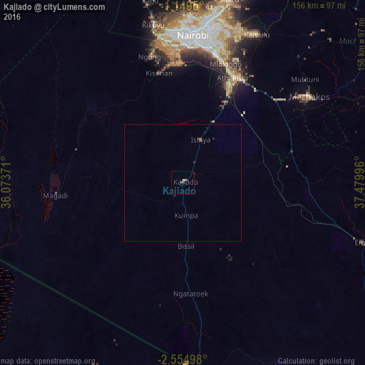
Analysis of Kajiado night lights 2016
Square area 10x10 km:
100  0%
0%
90-99 0%
80-89 0.87%
70-79 0%
60-69 0.87%
50-59 0.43%
40-49 1.3%
30-39 0.43%
20-29 0.87%
10-19 0%
0-9 95.24%
0%90-99
0%80-89
0.87%70-79
0%60-69
0.87%50-59
0.43%40-49
1.3%30-39
0.43%20-29
0.87%10-19
0%0-9
95.24%Square area 50x50 km:
100 0%
90-99 0%
80-89 0.03%
70-79 0%
60-69 0.04%
50-59 0.04%
40-49 0.1%
30-39 0.06%
20-29 0.1%
10-19 0.07%
0-9 99.55%
0%90-99
0%80-89
0.03%70-79
0%60-69
0.04%50-59
0.04%40-49
0.1%30-39
0.06%20-29
0.1%10-19
0.07%0-9
99.55%Clear (daylight) street map image can be seen on geolist.org.
Map coordinates:
1° 8' 58.2" South, 36° 4' 25.4" East
1° 51' 8.6" South, 36° 46' 36.6" East
2° 33' 17.9" South, 37° 28' 47.9" East
Some cities around Kajiado sort by population:
• Nairobi
63.4 km =39.4 mi,  4°
4°
• Machakos
65.5 km =40.7 mi,  55°
55°
• Pumwani
63.8 km =39.6 mi,  7°
7°
• Athi River
49.4 km =30.7 mi,  26°
26°
• Kiambu
76 km =47.2 mi, 4°
• Magadi
54.7 km =34 mi,  264°
264°
• Namanga, TZ
77.7 km =48.3 mi,  179°
179°
• Ngong
56.8 km =35.3 mi,  347°
347°
195298 (p: 11,198)
Sources (retrieved 2019-11-25):
» Earth at Night: Flat Maps 2012, 2016