Limuru night lights from space
Night Light of Limuru (Kiambu) from space (Kenya) Src. Average luminocity for 10x10km area is 5.5108% and for 50x50km: 13.7974%.
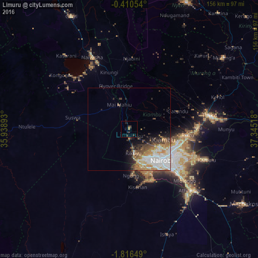
Analysis of Limuru night lights 2016
Square area 10x10 km:
 0%
0%90-99
0%80-89
0%70-79
0.87%60-69
0.87%50-59
0%40-49
3.9%30-39
1.52%20-29
1.73%10-19
4.11%0-9
87.01%Square area 50x50 km:
3.35%90-99
3.18%80-89
1.35%70-79
1.82%60-69
2.41%50-59
1.21%40-49
2.13%30-39
1.23%20-29
1.96%10-19
3.37%0-9
77.99%Clear (daylight) street map image can be seen on geolist.org.
Map coordinates:
0° 24' 37.9" South, 35° 56' 20.1" East
1° 6' 49" South, 36° 38' 31.4" East
1° 48' 59.4" South, 37° 20' 42.6" East
Some cities around Limuru sort by population:
• Nairobi
27.1 km =16.8 mi,  134°
134°
• Thika
48.3 km =30 mi,  79°
79°
• Naivasha
50.2 km =31.2 mi,  332°
332°
• Pumwani
29.8 km =18.5 mi, 129°
• Athi River
53.4 km =33.2 mi,  135°
135°
• Kiambu
22.5 km =14 mi,  106°
106°
• Murang’a
71.6 km =44.5 mi,  52°
52°
• Ngong
26.8 km =16.7 mi,  173°
173°
189386 (p: 6,317)
Sources (retrieved 2019-11-25):
» Earth at Night: Flat Maps 2012, 2016