Yōkaichiba night lights from space
Night Light of Yōkaichiba (Chiba) from space (Japan) Src. Average luminocity for 10x10km area is 12.3514% and for 50x50km: 15.5108%.
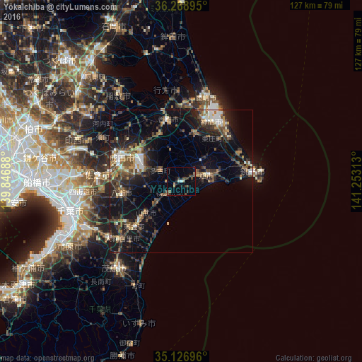

Analysis of Yōkaichiba night lights 2016
Square area 10x10 km:
 0.52%
0.52%90-99
1.05%80-89
0.52%70-79
1.4%60-69
0.7%50-59
1.92%40-49
5.77%30-39
1.92%20-29
3.32%10-19
4.37%0-9
78.5%Square area 50x50 km:
1.4%90-99
1.91%80-89
1.14%70-79
1.58%60-69
2.11%50-59
2.67%40-49
3.68%30-39
3.59%20-29
5.38%10-19
12.16%0-9
64.38%Clear (daylight) street map image can be seen on geolist.org.
Map coordinates:
36° 16' 8.2" North, 139° 50' 48.8" East
35° 42' 0" North, 140° 33' 0" East
35° 7' 37.1" North, 141° 15' 11.3" East
Some cities around Yōkaichiba sort by population:
• Narita
23 km =14.3 mi,  293°
293°
• Yachimata
21.8 km =13.5 mi,  255°
255°
• Katori-shi
22.4 km =13.9 mi,  348°
348°
• Tōgane
23.5 km =14.6 mi,  224°
224°
• Sawara
20.9 km =13 mi, 347°
• Asahi
9.2 km =5.7 mi,  78°
78°
• Omigawa
17.7 km =11 mi,  19°
19°
• Narutō
16.4 km =10.2 mi,  227°
227°
2110518 (p: 32,651)
Sources (retrieved 2019-11-25):
» Earth at Night: Flat Maps 2012, 2016