Makurazaki night lights from space
Night Light of Makurazaki (Kagoshima) from space (Japan) Src. Average luminocity for 10x10km area is 7.8619% and for 50x50km: 1.1943%.

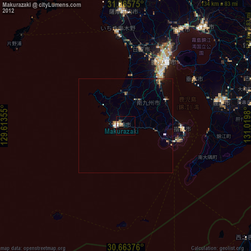
Analysis of Makurazaki night lights 2016
Square area 10x10 km:
 1.05%
1.05%90-99
1.05%80-89
1.4%70-79
0.17%60-69
1.92%50-59
0.87%40-49
0.7%30-39
2.27%20-29
1.05%10-19
0.7%0-9
88.81%Square area 50x50 km:
0.07%90-99
0.2%80-89
0.15%70-79
0.09%60-69
0.16%50-59
0.24%40-49
0.12%30-39
0.26%20-29
0.22%10-19
0.6%0-9
97.88%Clear (daylight) street map image can be seen on geolist.org.
Map coordinates:
31° 51' 56.7" North, 129° 36' 48.8" East
31° 16' 0" North, 130° 19' 0" East
30° 39' 49.5" North, 131° 1' 11.3" East
Some cities around Makurazaki sort by population:
• Kagoshima
40 km =24.9 mi,  33°
33°
• Kanoya
52.3 km =32.5 mi,  75°
75°
• Satsumasendai
61.2 km =38 mi,  358°
358°
• Ibusuki
31.9 km =19.8 mi,  96°
96°
• Kushikino
50.3 km =31.3 mi,  354°
354°
• Ijūin
39.7 km =24.7 mi,  11°
11°
• Kaseda-shirakame
16.7 km =10.4 mi,  0°
0°
• Tarumizu
43.6 km =27.1 mi,  56°
56°
1857712 (p: 24,971)
Sources (retrieved 2019-11-25):
» Earth at Night: Flat Maps 2012, 2016