Edosaki night lights from space
Night Light of Edosaki (Ibaraki) from space (Japan) Src. Average luminocity for 10x10km area is 14.2601% and for 50x50km: 27.1604%.
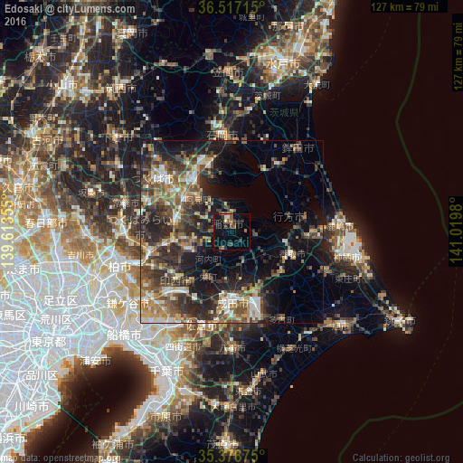

Analysis of Edosaki night lights 2016
Square area 10x10 km:
 0%
0%90-99
1.47%80-89
0.92%70-79
0.55%60-69
2.93%50-59
2.93%40-49
2.38%30-39
4.4%20-29
3.48%10-19
17.22%0-9
63.74%Square area 50x50 km:
2.26%90-99
3.88%80-89
2.56%70-79
3.51%60-69
4.6%50-59
5.5%40-49
6.25%30-39
6.57%20-29
10.32%10-19
12.28%0-9
42.27%Clear (daylight) street map image can be seen on geolist.org.
Map coordinates:
36° 31' 1.7" North, 139° 36' 48.8" East
35° 57' 0" North, 140° 19' 0" East
35° 22' 43.5" North, 141° 1' 11.3" East
Some cities around Edosaki sort by population:
• Ryūgasaki
13.2 km =8.2 mi,  245°
245°
• Katori-shi
17.5 km =10.9 mi,  109°
109°
• Ushiku
16.6 km =10.3 mi,  276°
276°
• Ami
14 km =8.7 mi,  311°
311°
• Sawara
18.1 km =11.2 mi, 114°
• Inashiki
0.9 km =0.6 mi,  41°
41°
• Naka
17.5 km =10.9 mi, 309°
• Fujishiro
18.4 km =11.4 mi,  258°
258°
2112963 (p: 20,800)
Sources (retrieved 2019-11-25):
» Earth at Night: Flat Maps 2012, 2016