Aţ Ţurrah night lights from space
Night Light of Aţ Ţurrah (Irbid) from space (Jordan) Src. Average luminocity for 10x10km area is 32.9878% and for 50x50km: 26.4387%.
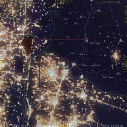
Analysis of Aţ Ţurrah night lights 2016
Square area 10x10 km:
 1.92%
1.92%90-99
3.67%80-89
4.9%70-79
6.99%60-69
1.75%50-59
1.92%40-49
8.22%30-39
11.36%20-29
18.36%10-19
23.08%0-9
17.83%Square area 50x50 km:
1.99%90-99
2.56%80-89
6.46%70-79
5.1%60-69
3.22%50-59
4.49%40-49
6.11%30-39
5.14%20-29
7.82%10-19
8.65%0-9
48.45%Clear (daylight) street map image can be seen on geolist.org.
Map coordinates:
33° 13' 47.7" North, 35° 17' 10.7" East
32° 38' 23.2" North, 35° 59' 21.9" East
32° 2' 44.7" North, 36° 41' 33.2" East
Some cities around Aţ Ţurrah sort by population:
• Irbid
16.1 km =10 mi,  234°
234°
• Dar‘ā, SY
10.8 km =6.7 mi,  102°
102°
• Ar Ramthā
9.2 km =5.7 mi,  168°
168°
• Ţafas, SY
13 km =8.1 mi,  33°
33°
• Ash Shajarah
4.5 km =2.8 mi,  275°
275°
• Ḩakamā
11.2 km =7 mi,  242°
242°
• Sāl
10.7 km =6.6 mi,  222°
222°
• Kharjā
9.8 km =6.1 mi, 283°
250179 (p: 14,619)
Sources (retrieved 2019-11-25):
» Earth at Night: Flat Maps 2012, 2016