Ḩakamā night lights from space
Night Light of Ḩakamā (Irbid) from space (Jordan) Src. Average luminocity for 10x10km area is 74.1451% and for 50x50km: 33.8618%.
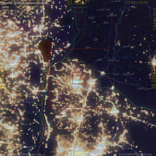
Analysis of Ḩakamā night lights 2016
Square area 10x10 km:
100  13.64%
90-99 12.41%
80-89 20.63%
70-79 14.51%
60-69 10.49%
50-59 16.78%
40-49 6.29%
30-39 4.9%
20-29 0.35%
10-19 0%
0-9 0%
13.64%90-99
12.41%80-89
20.63%70-79
14.51%60-69
10.49%50-59
16.78%40-49
6.29%30-39
4.9%20-29
0.35%10-19
0%0-9
0%Square area 50x50 km:
100 2.14%
90-99 2.94%
80-89 7.73%
70-79 6.5%
60-69 4.11%
50-59 5.37%
40-49 8.65%
30-39 7.02%
20-29 12.01%
10-19 15.64%
0-9 27.89%
2.14%90-99
2.94%80-89
7.73%70-79
6.5%60-69
4.11%50-59
5.37%40-49
8.65%30-39
7.02%20-29
12.01%10-19
15.64%0-9
27.89%Clear (daylight) street map image can be seen on geolist.org.
Map coordinates:
33° 11' 2.3" North, 35° 10' 48.3" East
32° 35' 36.7" North, 35° 52' 59.5" East
31° 59' 57.1" North, 36° 35' 10.8" East
Some cities around Ḩakamā sort by population:
• Irbid
5.2 km =3.2 mi,  216°
216°
• Aydūn
10.1 km =6.3 mi,  193°
193°
• Aţ Ţurrah
11.2 km =7 mi,  62°
62°
• Ash Shajarah
7.8 km =4.8 mi,  44°
44°
• Bayt Yāfā
12 km =7.5 mi,  229°
229°
• Sāl
3.8 km =2.4 mi,  135°
135°
• Ḩātim
11.4 km =7.1 mi,  300°
300°
• Kharjā
7.4 km =4.6 mi,  3°
3°
249318 (p: 7,075)
Sources (retrieved 2019-11-25):
» Earth at Night: Flat Maps 2012, 2016