Sāl night lights from space
Night Light of Sāl (Irbid) from space (Jordan) Src. Average luminocity for 10x10km area is 68.7203% and for 50x50km: 36.0514%.
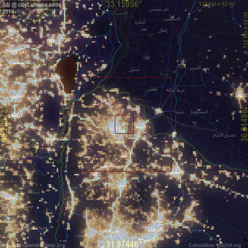
Analysis of Sāl night lights 2016
Square area 10x10 km:
100  10.84%
90-99 14.16%
80-89 14.69%
70-79 11.19%
60-69 7.52%
50-59 15.56%
40-49 14.69%
30-39 9.97%
20-29 1.4%
10-19 0%
0-9 0%
10.84%90-99
14.16%80-89
14.69%70-79
11.19%60-69
7.52%50-59
15.56%40-49
14.69%30-39
9.97%20-29
1.4%10-19
0%0-9
0%Square area 50x50 km:
100 2.35%
90-99 3.2%
80-89 8.17%
70-79 7.09%
60-69 4.68%
50-59 5.79%
40-49 9.59%
30-39 7.68%
20-29 12.93%
10-19 12.12%
0-9 26.38%
2.35%90-99
3.2%80-89
8.17%70-79
7.09%60-69
4.68%50-59
5.79%40-49
9.59%30-39
7.68%20-29
12.93%10-19
12.12%0-9
26.38%Clear (daylight) street map image can be seen on geolist.org.
Map coordinates:
33° 9' 34.4" North, 35° 12' 31.4" East
32° 34' 8.3" North, 35° 54' 42.7" East
31° 58' 28.1" North, 36° 36' 53.9" East
Some cities around Sāl sort by population:
• Irbid
6 km =3.7 mi,  255°
255°
• Ar Ramthā
9.1 km =5.7 mi,  97°
97°
• Aydūn
8.7 km =5.4 mi,  215°
215°
• Aţ Ţurrah
10.7 km =6.6 mi,  42°
42°
• Ash Shajarah
8.8 km =5.5 mi,  18°
18°
• Bayt Yāfā
12.9 km =8 mi,  246°
246°
• Ḩakamā
3.8 km =2.4 mi,  315°
315°
• Kharjā
10.4 km =6.5 mi,  347°
347°
247061 (p: 6,896)
Sources (retrieved 2019-11-25):
» Earth at Night: Flat Maps 2012, 2016