Vallecrosia night lights from space
Night Light of Vallecrosia (Liguria) from space (Italy) Src. Average luminocity for 10x10km area is 36.6939% and for 50x50km: 9.0834%.
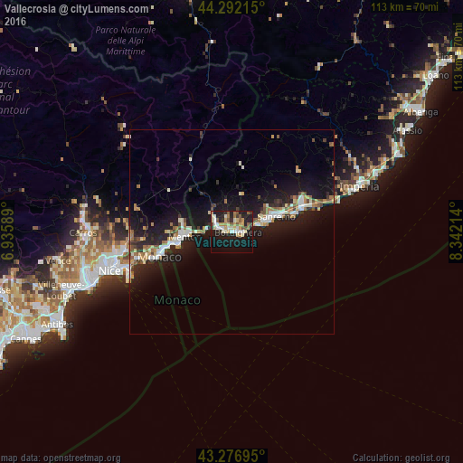
Analysis of Vallecrosia night lights 2016
Square area 10x10 km:
 3.94%
3.94%90-99
8.48%80-89
4.55%70-79
5.45%60-69
5.15%50-59
5.3%40-49
2.88%30-39
1.97%20-29
9.24%10-19
36.21%0-9
16.82%Square area 50x50 km:
1.05%90-99
1.67%80-89
0.78%70-79
0.97%60-69
1.42%50-59
0.99%40-49
1.01%30-39
0.7%20-29
2.73%10-19
11.09%0-9
77.6%Clear (daylight) street map image can be seen on geolist.org.
Map coordinates:
44° 17' 31.7" North, 6° 56' 9.2" East
43° 47' 12.2" North, 7° 38' 20.5" East
43° 16' 37" North, 8° 20' 31.7" East
Some cities around Vallecrosia sort by population:
• San Remo
11.6 km =7.2 mi,  72°
72°
• Menton, FR
10.9 km =6.8 mi,  263°
263°
• Ventimiglia
2.5 km =1.6 mi,  277°
277°
• Monte-Carlo, MC
17.8 km =11.1 mi,  252°
252°
• Beausoleil, FR
18 km =11.2 mi, 254°
• Taggia
18.3 km =11.4 mi, 68°
• Roquebrune-Cap-Martin, FR
12.8 km =8 mi, 258°
• Bordighera
2.2 km =1.4 mi,  108°
108°
3164862 (p: 6,024)
Sources (retrieved 2019-11-25):
» Earth at Night: Flat Maps 2012, 2016