Beausoleil night lights from space
Night Light of Beausoleil (Provence-Alpes-Côte d'Azur) from space (France) Src. Average luminocity for 10x10km area is 41.0152% and for 50x50km: 16.2248%.
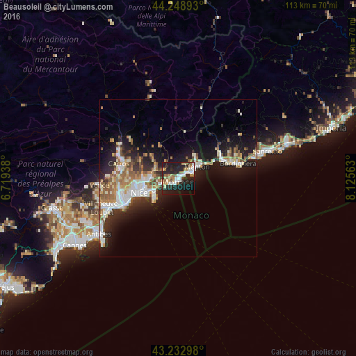
Analysis of Beausoleil night lights 2016
Square area 10x10 km:
 7.42%
7.42%90-99
8.64%80-89
4.09%70-79
3.48%60-69
7.58%50-59
3.94%40-49
2.73%30-39
1.97%20-29
23.94%10-19
28.94%0-9
7.27%Square area 50x50 km:
2.88%90-99
3.45%80-89
1.38%70-79
1.78%60-69
2.38%50-59
2.25%40-49
1.6%30-39
1.73%20-29
4.89%10-19
10.94%0-9
66.7%Clear (daylight) street map image can be seen on geolist.org.
Map coordinates:
44° 14' 56.1" North, 6° 43' 9.8" East
43° 44' 35.2" North, 7° 25' 21" East
43° 13' 58.7" North, 8° 7' 32.3" East
Some cities around Beausoleil sort by population:
• Monaco, MC
1.2 km =0.7 mi,  203°
203°
• Menton
7.5 km =4.7 mi,  60°
60°
• Monte-Carlo, MC
0.5 km =0.3 mi,  133°
133°
• La Condamine, MC
1 km =0.6 mi,  190°
190°
• Roquebrune-Cap-Martin
5.3 km =3.3 mi, 64°
• La Trinité
8.7 km =5.4 mi,  268°
268°
• Villefranche-sur-Mer
10 km =6.2 mi,  244°
244°
• Contes
11.6 km =7.2 mi,  311°
311°
3034041 (p: 13,376)
Sources (retrieved 2019-11-25):
» Earth at Night: Flat Maps 2012, 2016