Monte-Carlo night lights from space
Night Light of Monte-Carlo from space (Monaco) Src. Average luminocity for 10x10km area is 39.4182% and for 50x50km: 16.0494%.
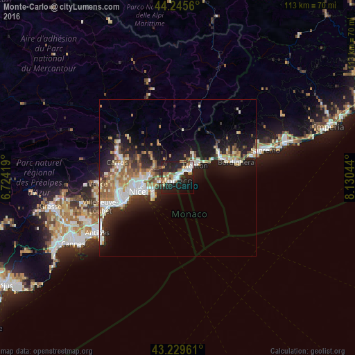
Analysis of Monte-Carlo night lights 2016
Square area 10x10 km:
 7.73%
7.73%90-99
8.79%80-89
3.18%70-79
3.18%60-69
6.97%50-59
3.64%40-49
2.12%30-39
1.97%20-29
23.03%10-19
28.48%0-9
10.91%Square area 50x50 km:
2.83%90-99
3.41%80-89
1.36%70-79
1.75%60-69
2.39%50-59
2.2%40-49
1.58%30-39
1.72%20-29
4.88%10-19
10.93%0-9
66.96%Clear (daylight) street map image can be seen on geolist.org.
Map coordinates:
44° 14' 44.2" North, 6° 43' 27.1" East
43° 44' 23.1" North, 7° 25' 38.4" East
43° 13' 46.6" North, 8° 7' 49.6" East
Some cities around Monte-Carlo sort by population:
• Monaco
1.1 km =0.7 mi,  230°
230°
• Menton, FR
7.4 km =4.6 mi,  56°
56°
• Beausoleil, FR
0.5 km =0.3 mi,  313°
313°
• La Condamine
0.8 km =0.5 mi,  223°
223°
• Roquebrune-Cap-Martin, FR
5.2 km =3.2 mi, 58°
• La Trinité, FR
9.1 km =5.7 mi,  270°
270°
• Villefranche-sur-Mer, FR
10.2 km =6.3 mi,  246°
246°
• Contes, FR
12.2 km =7.6 mi, 311°
2992741 (p: 16,012)
Sources (retrieved 2019-11-25):
» Earth at Night: Flat Maps 2012, 2016