Roquebrune-Cap-Martin night lights from space
Night Light of Roquebrune-Cap-Martin (Provence-Alpes-Côte d'Azur) from space (France) Src. Average luminocity for 10x10km area is 38.3197% and for 50x50km: 14.2231%.
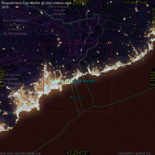
Analysis of Roquebrune-Cap-Martin night lights 2016
Square area 10x10 km:
 8.79%
8.79%90-99
10.3%80-89
1.82%70-79
1.67%60-69
5.91%50-59
3.03%40-49
3.03%30-39
1.06%20-29
15.3%10-19
37.12%0-9
11.97%Square area 50x50 km:
2.54%90-99
3.06%80-89
1.12%70-79
1.59%60-69
2.12%50-59
1.65%40-49
1.43%30-39
1.44%20-29
4.13%10-19
10.67%0-9
70.26%Clear (daylight) street map image can be seen on geolist.org.
Map coordinates:
44° 16' 11" North, 6° 46' 44.2" East
43° 45' 50.7" North, 7° 28' 55.5" East
43° 15' 14.9" North, 8° 11' 6.7" East
Some cities around Roquebrune-Cap-Martin sort by population:
• Monaco, MC
6.3 km =3.9 mi,  236°
236°
• Menton
2.3 km =1.4 mi,  52°
52°
• Ventimiglia, IT
10.6 km =6.6 mi,  74°
74°
• Monte-Carlo, MC
5.2 km =3.2 mi, 238°
• Beausoleil
5.3 km =3.3 mi, 244°
• La Condamine, MC
6 km =3.7 mi, 236°
• La Trinité
13.8 km =8.6 mi,  259°
259°
• Vallecrosia, IT
12.8 km =8 mi,  78°
78°
2982876 (p: 11,834)
Sources (retrieved 2019-11-25):
» Earth at Night: Flat Maps 2012, 2016