Tavarnelle Val di Pesa night lights from space
Night Light of Tavarnelle Val di Pesa (Tuscany) from space (Italy) Src. Average luminocity for 10x10km area is 11.4206% and for 50x50km: 16.3128%.
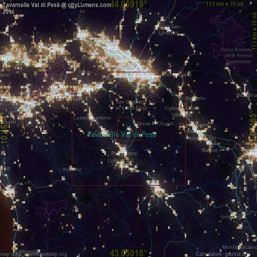
Analysis of Tavarnelle Val di Pesa night lights 2016
Square area 10x10 km:
 0.79%
0.79%90-99
2.7%80-89
0.63%70-79
0.63%60-69
0%50-59
1.9%40-49
1.11%30-39
3.49%20-29
2.06%10-19
2.7%0-9
83.97%Square area 50x50 km:
2.5%90-99
3.06%80-89
1.46%70-79
1.24%60-69
1.63%50-59
2.15%40-49
2.46%30-39
2.04%20-29
5.65%10-19
12.1%0-9
65.72%Clear (daylight) street map image can be seen on geolist.org.
Map coordinates:
44° 4' 9.1" North, 10° 28' 6.2" East
43° 33' 42.6" North, 11° 10' 17.5" East
43° 3' 0.6" North, 11° 52' 28.7" East
Some cities around Tavarnelle Val di Pesa sort by population:
• Scandicci
21.4 km =13.3 mi,  3°
3°
• Poggibonsi
10.3 km =6.4 mi,  190°
190°
• Colle di Val d'Elsa
16.1 km =10 mi, 192°
• Certaldo
10.8 km =6.7 mi,  261°
261°
• Castelfiorentino
17.3 km =10.7 mi,  287°
287°
• Montelupo Fiorentino
22.7 km =14.1 mi,  325°
325°
• Grassina Ponte a Ema
21.7 km =13.5 mi,  28°
28°
• San Casciano in Val di Pesa
10.9 km =6.8 mi,  5°
5°
6534685 (p: 7,153)
Sources (retrieved 2019-11-25):
» Earth at Night: Flat Maps 2012, 2016