Montelupo Fiorentino night lights from space
Night Light of Montelupo Fiorentino (Tuscany) from space (Italy) Src. Average luminocity for 10x10km area is 35.9818% and for 50x50km: 32.0125%.
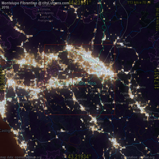
Analysis of Montelupo Fiorentino night lights 2016
Square area 10x10 km:
 4.85%
4.85%90-99
5.91%80-89
4.24%70-79
2.58%60-69
4.55%50-59
3.94%40-49
4.55%30-39
6.06%20-29
21.36%10-19
35.45%0-9
6.52%Square area 50x50 km:
6.49%90-99
6.54%80-89
2.48%70-79
2.92%60-69
3.71%50-59
4.64%40-49
4.76%30-39
4.31%20-29
11.74%10-19
16.38%0-9
36.02%Clear (daylight) street map image can be seen on geolist.org.
Map coordinates:
44° 14' 7.8" North, 10° 18' 24.7" East
43° 43' 46.5" North, 11° 0' 35.9" East
43° 13' 9.6" North, 11° 42' 47.2" East
Some cities around Montelupo Fiorentino sort by population:
• Empoli
5.2 km =3.2 mi,  255°
255°
• Signa
10.4 km =6.5 mi,  46°
46°
• Lastra a Signa
9.4 km =5.8 mi,  61°
61°
• Spicchio-Sovigliana
5.7 km =3.5 mi,  270°
270°
• Poggio A Caiano
9.9 km =6.2 mi,  19°
19°
• Seano
11.2 km =7 mi,  4°
4°
• Capraia e Limite
2.8 km =1.7 mi,  309°
309°
• San Donnino
13.2 km =8.2 mi, 56°
3172861 (p: 11,177)
Sources (retrieved 2019-11-25):
» Earth at Night: Flat Maps 2012, 2016