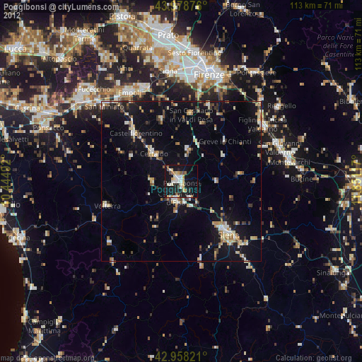
Poggibonsi night lights from space
Night Light of Poggibonsi (Tuscany) from space (Italy) Src. Average luminocity for 10x10km area is 27.9365% and for 50x50km: 9.4071%.

Analysis of Poggibonsi night lights 2016
Square area 10x10 km:
 4.6%
4.6%90-99
5.08%80-89
3.81%70-79
2.86%60-69
0.79%50-59
3.33%40-49
0.95%30-39
2.86%20-29
8.25%10-19
45.56%0-9
21.9%Square area 50x50 km:
0.82%90-99
1.5%80-89
1.02%70-79
0.71%60-69
0.94%50-59
1.07%40-49
1.36%30-39
1.31%20-29
2.46%10-19
9.38%0-9
79.42%Clear (daylight) street map image can be seen on geolist.org.
Map coordinates:
43° 58' 43.5" North, 10° 26' 41.7" East
43° 28' 14.3" North, 11° 8' 52.9" East
42° 57' 29.6" North, 11° 51' 4.2" East
Some cities around Poggibonsi sort by population:
• Siena
22.5 km =14 mi,  138°
138°
• Colle di Val d'Elsa
5.8 km =3.6 mi,  196°
196°
• Figline Valdarno
30.9 km =19.2 mi,  57°
57°
• Certaldo
12.3 km =7.6 mi,  314°
314°
• Castelfiorentino
21.2 km =13.2 mi,  316°
316°
• Tavarnelle Val di Pesa
10.3 km =6.4 mi,  10°
10°
• Volterra
24.3 km =15.1 mi,  251°
251°
• San Casciano in Val di Pesa
21.2 km =13.2 mi, 8°
3170504 (p: 21,692)
Sources (retrieved 2019-11-25):
» Earth at Night: Flat Maps 2012, 2016