Grassina Ponte a Ema night lights from space
Night Light of Grassina Ponte a Ema (Tuscany) from space (Italy) Src. Average luminocity for 10x10km area is 47.0273% and for 50x50km: 22.6587%.
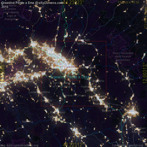
Analysis of Grassina Ponte a Ema night lights 2016
Square area 10x10 km:
 10%
10%90-99
11.67%80-89
4.7%70-79
0.76%60-69
6.82%50-59
5.91%40-49
9.24%30-39
5.91%20-29
15.61%10-19
21.67%0-9
7.73%Square area 50x50 km:
5.1%90-99
4.91%80-89
1.52%70-79
1.81%60-69
2.46%50-59
3.17%40-49
2.8%30-39
2.72%20-29
5.69%10-19
12.15%0-9
57.66%Clear (daylight) street map image can be seen on geolist.org.
Map coordinates:
44° 14' 21.2" North, 10° 35' 48.8" East
43° 43' 60" North, 11° 18' 0" East
43° 13' 23.2" North, 12° 0' 11.3" East
Some cities around Grassina Ponte a Ema sort by population:
• Florence
6.7 km =4.2 mi,  319°
319°
• Sesto Fiorentino
13.6 km =8.5 mi, 323°
• Scandicci
9.3 km =5.8 mi,  284°
284°
• Lastra a Signa
15.6 km =9.7 mi,  285°
285°
• Pontassieve
11.5 km =7.1 mi,  66°
66°
• San Casciano in Val di Pesa
12.3 km =7.6 mi,  228°
228°
• San Donnino
14.1 km =8.8 mi,  299°
299°
• Bagno a Ripoli
2.7 km =1.7 mi,  42°
42°
3170305 (p: 8,412)
Sources (retrieved 2019-11-25):
» Earth at Night: Flat Maps 2012, 2016