Castelfiorentino night lights from space
Night Light of Castelfiorentino (Tuscany) from space (Italy) Src. Average luminocity for 10x10km area is 17.803% and for 50x50km: 23.4275%.
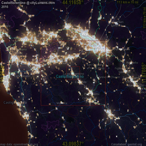
Analysis of Castelfiorentino night lights 2016
Square area 10x10 km:
 1.06%
1.06%90-99
1.97%80-89
4.09%70-79
0.76%60-69
0.3%50-59
2.88%40-49
3.79%30-39
1.06%20-29
1.97%10-19
26.36%0-9
55.76%Square area 50x50 km:
4.05%90-99
4.54%80-89
2.08%70-79
2.3%60-69
2.4%50-59
3.09%40-49
3.27%30-39
3.38%20-29
9.25%10-19
15.35%0-9
50.28%Clear (daylight) street map image can be seen on geolist.org.
Map coordinates:
44° 6' 59.7" North, 10° 15' 52.6" East
43° 36' 34.7" North, 10° 58' 3.8" East
43° 5' 54.1" North, 11° 40' 15.1" East
Some cities around Castelfiorentino sort by population:
• Empoli
12.2 km =7.6 mi,  352°
352°
• San Miniato Basso
13.8 km =8.6 mi,  312°
312°
• San Miniato
12.3 km =7.6 mi, 309°
• Certaldo
9 km =5.6 mi,  140°
140°
• Montelupo Fiorentino
13.8 km =8.6 mi,  14°
14°
• Spicchio-Sovigliana
13.6 km =8.5 mi, 350°
• Tavarnelle Val di Pesa
17.3 km =10.7 mi,  107°
107°
• Capraia e Limite
15.1 km =9.4 mi,  4°
4°
3179696 (p: 12,656)
Sources (retrieved 2019-11-25):
» Earth at Night: Flat Maps 2012, 2016